Chilly again tonight as a mostly clear sky and a calming wind will allow temperatures to drop into the upper 40s along the coast to upper 30s to low 40s inland. A few high clouds will continue to stream across the sky creating at times a halo effect around the full moon...a neat sight to behold!
Temperatures will rebound into tomorrow afternoon as the surface wind shifts out of the southeast and high pressure sets up over the peninsula allowing highs to reach up to near 70 degrees along the coast to mid 70s inland. With the center of high pressure in close proximity, winds will be lighter through the day and sunshine plentiful accompanied by a few high clouds. Those high clouds though will be a harbinger of rain in the forecast...Monday night expect increasing cloud cover and a chance of isolated rain.
And unpleasant weather day is in the forecast for Tuesday as a closed area of low pressure moves east across the state. Rain likely primarily through the afternoon period...will have you utilizing the ol' umbrella though windy conditions may have your umbrella turned inside out with wind speeds at 20-25 mph with higher gusts! The bulk of the precipitation will end Tuesday evening though a few showers may linger into the first part of Tuesday night.
Have a great week!
Lauren
Sunday, February 28, 2010
Saturday, February 27, 2010
After a cool and rainy day, another cold night is in store...but sunshine returns for Sunday!
The high temperature in Ft. Myers was the coolest on record for today's date, reaching only to 57 degrees replacing the old record of 60 degrees from 1963! Combining the cool air with the rain...made for a less than pleasant start to the weekend although conditions today were not quite as dreary for folks in Collier county which tallied the lowest rainfall totals and high temperatures about 10 degrees warmer than those in Lee and Charlotte, due to a warm front that passed through Collier and came to a halt.
A cold front has made passage through all of SWFL ensuring another night of cold temperatures for all. Expect overnight lows in the upper 40's to near 50 degrees along the coast with some variation for inland temperatures...expect mid 40's for inland Collier but colder north with low 40's to upper 30's. A Wind Chill Advisory is in effect through 8 am tomorrow morning for DeSoto and Highlands counties due to the cold lows and a north wind near 10 mph.
A few clouds will be possible tomorrow morning but plentiful sunshine is on tap for our Sunday afternoon as high pressure continue to settle in. High temperatures will be well-below average, in the mid 60's but the sunny sky and low humidity...will make for a pleasant end to the weekend!
Cold again for Monday morning, but a shift to a southeasterly surface flow will permit a warmer afternoon with highs in the low 70's under a mostly sunny sky.
Have a great night!
Lauren
Friday, February 26, 2010
Scott: Rain for your Saturday and cool temperatures as well. Might see an isolated storm too. Detail @ 6, 7, 10 & 11.
Another fast moving system moving into the area for Saturday afternoon. You can expect to see 3 hours of rain as this cold front quickly moves through. On average about .50 inch expected. A cool day too, highs only expected to get in to the upper 50's and low 60's. Sunday will be better with a lot of sun but still on the cool side. Warmer by Monday afternoon, but rain moves back in Tuesday morning! Details at 6 and 7!
--
Scott Zedeker
WINK TV Meteorologist
--
Scott Zedeker
WINK TV Meteorologist
Brian: Big winter storm for northeast means chilly weather sticks around for us..
Temperatures are starting to rebound now off of morning lows, with temperatures now climbing into the 40's for most of southwest Florida. We started at 43 in Naples and Fort Myers this morning, but lows in most inland locations dipped into the 30's. It will not be as cold tomorrow morning with clouds moving in ahead of our next chance of rain; most of us will start in the mid to upper 40's Saturday.
You'll want to watch Lauren Casey at midday and Scott Zedeker this evening for the latest on our rain chance tomorrow. Rain looks likely now.. the tricky part of the forecast is temperatures are they'll have the latest model information for you. Remember, the track of the low will be crucial. A farther north track and we end up near 70 tomorrow.. farther south? We'll be stuck in the low to mid 60's.
By the way, what a strange major winter storm in the northeast. Take this report from the National Weather Service in NYC... reporting all of the heavy rain totals north and east of the center of low pressure and all of the snow south and west of the center of low pressure! Parts of Connecticut saw almost 3" of rain while their neighbors to the south in the New York City area saw more than two feet of snow! This was all the result of low pressure "retrograding" to the west... instead of moving to the northeast as these storms usually do. This allowed warm Atlantic Ocean air to surge inland toward southern New England north of the low, and cold Canadian air to push into NYC on the south side of the low. The unusual happenings of this winter continue!
Brian
Brian: Temps starting in the 30's inland, 40's at the coast
Good Friday morning! It's a cold start to the last day of the work week, the last Friday in Februrary (already!), as temperatures this morning are in the mid 30's inland and 40's along the coast. There is a freeze warning for most of our inland areas until 8 AM but most areas should stay just above the freezing mark. It should be a gorgeous day today across the area with a mostly sunny sky and highs in the mid to upper 60's.. just the hint of a few high clouds developing later today ahead of our next system.
Clouds will increase tonight as low pressure moves into the eastern Gulf. By tomorrow morning, late, showers should start pushing into the area from the west and be with us through mid to late afternoon. This is quick-moving low pressure though and, by Saturday evening, we should begin clearing out. Temps will be a bit tricky tomorrow but, at this point, most of our models are tracking low pressure right across SWFL.. which should keep temperatures in the mid to low 60's for most of us. If the low tracks a little farther north, we might be able to get into the upper 60's to near 70 before the rain in especially Collier County. There's a little of upper level energy that'll be moving through with this low, too.. so it appears likely we'll get anywhere from .25" to .50" of rain with this one.
Clouds might linger a bit on Sunday morning, otherwise Sunday is the pick of the weekend with a mostly sunny afternoon and highs in the mid 60's. Have a great weekend!
Brian
Thursday, February 25, 2010
Scott: Cold tonight! Temps in the 30's for most of us! inland freeze warning in effect too! also rain on the weekend is expected. Details at 5pm.
Cold temperatures are expected overnight. Many of us including downtown Fort Myers will drop into the 30's. There is a inland freeze warning for all areas East of 75. Take the proper precautions for your vegitation. Freeze warning means at least 3 hours of temperatures at 27 to 32 degrees. We will warm up slightly Friday, middle 60's. More rain in the forecast Saturday. Could even see a few thunderstorms. It just depends on the expact track of the low pressure system. Breezy and cooler Sunday but sunny. Stay warm. Details starting at 5 with Jim. See you at 7 pm!
--
Scott Zedeker
WINK TV Meteorologist
--
Scott Zedeker
WINK TV Meteorologist
Cold Again
Clear and cold tonight with low temperatures near 40 degrees. Mostly sunny and cool tomorrow, cold again tomorrow tonight. - Jim
Brian: A much cooler day in the forecast for Thursday!
What a change from yesterday! This time yesterday we had lots of low clouds and fog, with temps in the low to mid 60's. This morning? A howling northwest wind coming straight out of Canada (around yet another major winter storm in the Northeast) and temps that are falling out of the low 50's and into the 40's area wide. In fact, there's a wind chill advisory this morning across inland southwest Florida where temps are already in the low 40's this morning!
There are some clouds around this morning, these will move out over the next few hours and we end up with a mostly sunny sky today. The wind won't be quite as strong by the afternoon but it will be chilly today with temps in the upper 50's and low 60's. For tonight, the coldest air will be with us and with high pressure just to our northwest -- we'll end up with a mainly clear sky and light wind. What does that add up to? A cold night! Temperatures will fall to near freezing deep inland (around US-27 through Glades and Highlands, most notably).. to near 40 along the coast. High clouds move in ahead of our next storm tomorrow afternoon with temperatures climbing back toward the mid to upper 60's.
As the big winer storm continues to spin over the northeast (this one's going nowhere fast.. and it'll keep our pattern unsettled and cooler than average for several days!), our next front comes through on Saturday afternoon with rain likely Saturday night. Sunday clears out.. but clouds return Monday ahead of our next chance of rain Monday night and early Tuesday.
Brian
Wednesday, February 24, 2010
Scott: Rain ending around the area! Could see a fast moving shower or two thru the rest of the evening. Cooler weather ahead!
The rain is ending as the front pushes through the area. A strong northwesterly wind will be blowing up to 25 mph later this evening. That will bring in the cooler and drier weather for the next few days. Overnight temperatures will fall into the 40's and highs only expeted to get into the low 60's. Friday morning how about upper 30's and low 40's, cold again. We will warm up into the weekend slightly, but rain is back late Saturday. Sunday is looking sunny and cool, highs in the middle 60's! Details starting at 5. Watch me at 7 for your forecast.
--
Scott Zedeker
WINK TV Meteorologist
--
Scott Zedeker
WINK TV Meteorologist
Scattered rain and storms in store for this afternoon and evening. A few storms may be strong to severe with gusty winds, heavy rainfall and frequent lightning.
Keep yourself aware of quickly changing weather conditions today as the atmospheric set-up will allow a light shower to rapidly transform into a strong thunderstorm. Numerous storms will continue to flare up across SWFL through the remainder of the afternoon. The storm threat comes to an end this evening with lingering scattered rain possible through the early part of tonight. Winds will increase considerably into the evening hours to 15-20 mph with gusts to 30 mph possible. As the storms roll out, the cold air rolls back in. Temperatures overnight will plummet down into the low 50s along the coast to mid 40s inland under a clearing sky.
Watch for weather updates through the afternoon on WINK.
Lauren
Watch for weather updates through the afternoon on WINK.
Lauren
Brian: Yet Another Historic Storm in An Historic Winter!


Yet another major winter storm is getting ready to hammer away at parts of the northern Middle Atlantic and Northeast as we head toward the end of the week. In fact, there's kind of an "appetizer" snow happening now across parts of New York and interior New England where a foot to a foot and a half of snow could fall through tonight. That's just the warm up act for a storm that's being sensationalized in some quarters as a "snowicane".. one that will develop later tomorrow off the Northeast coast and head toward New York City.
Several things are coming together for this storm - most notably something called the polar vortex dropping out of Canada and spinning over the eastern Great Lakes. This will allow low pressure to explode near New York City tomorrow night (pulling it inland) -- bringing heavy snow to places like Philadelphia, PA; Scranton, PA; Binghamton, NY; Rochester, NY; and Albany, NY. Meantime, because the low pulls inland, a heavy, wind-swept rain will fall over much of southern New England. By the time all is said and done, 1-3 feet of snow could fall in the area from near Philadelphia up through upstate New York and into Vermont and, on the backside of the system, a 3-6" snow is possible over eastern New England after all of the heavy rain to start. Not to mention that, with low pressure rapidly intensifying, the wind will be howling across the northeast.. with gusts above 50 mph possible.
As far as those snow totals go, keep in mind that the positioning of low pressure is key. Any change in the position by only a mere 40 or 50 miles could be the difference between a heavy rain and a heavy snow. The models are coming into better focus now, but there is still some opportunity for changes in the forecast. Either way, travel will be severely disrupted Thursday/Friday and probably into the weekend through most of the northeast!
The big thing with this storm will be the staying power of it. After a wave of heavy, thumping snow Thursday.. the upper level low will become locked in place bringing wavesf additional light to moderate snow through early in the weekend across much of the northeast. That's important for us here in SWFL. As you can see above, that pattern will force the jet stream to the south bringing back a pattern of below average temperatures to the area. We'll see highs stuck in the low 60's tomorrow.. a freeze possible inland on Friday morning.. and upper 60's by Friday afternoon. Several new disturbances will rotate around the upper low stuck over the northeast, giving us the opportunity for precipitation every couple of days through the middle of next week!
Brian
Brian: Dense fog hanging around this morning..
Low clouds and areas of dense fog are shrouding SWFL this morning ahead of a cold front that brings huge changes to our weather later today. In some spots, visibility will be only a mile or two (if not less) for the next 30-60 minutes. We should break into some sunshine for a while this morning allowing temps to get into the 70's before the drop this afternoon. Also, watch out for a few isolated rain areas in parts of DeSoto and Highlands Counties this morning. More rain for everyone else later. Have a great day!
Brian
Brian: Areas of dense fog this morning, transition to cooler weather coming..
We're starting this morning with some fog again around southwest Florida; in fact, a dense fog advisory is in place for inland areas until about 9 AM. The fog will eventually burn off but, unlike yesterday, the low clouds will stick around just about all day. We may see a few breaks of sun before noon today, but after that clouds dominate as a cold front (a strong one this time!) moves in. This front should arrive early afternoon across Charlotte County and late afternoon across Collier County, bringing with it scattered showers and really whipping up a northwest wind later today. Early afternoon temps will be in the mid (if not upper in some places) 70's.. but late afternoon temps will crash through the 60's as the cold air funnels in.
Lots of sun tomorrow but much, much cooler.. highs will only be in the lower 60's! A cold night Thursday night with lows in the 30's and low 40's.. slightly warmer with some more clouds Friday at 68. More coming up on WINK in just a few minutes, see you there!
Brian
Tuesday, February 23, 2010
Scott: Rain moving back in for tomorrow. The 7 Day has a lot of ups and downs and three days feature rain. Find out at 6 & 7!
Well we are watching another system gathering strength in the Gulf. Rain will move into the area Wednesday afternoon. Could be as early as noon. After the rain moves out, the breeze will really pick up from the northwest. With that said, expect cooler weather for your Thursday. Morning and afternoon. This cooler weather will be around through Friday too. Then another system brings us rain Saturday! Sunday is looking cool and breezy but sunny. Details starting at 6 and see me at 7!
--
Scott Zedeker
WINK TV Meteorologist
--
Scott Zedeker
WINK TV Meteorologist
More Rain, Colder
Clouds will increase tonight as a new cold front approaches. Tomorrow will be a mostly cloudy, breezy day with rain likely. Colder tomorrow night. - Jim
Brian: Low clouds have broken up... temps headed for 80 degrees
Good afternoon! The low clouds and fog that were so stubborn to burn off this morning have finally eroded enough to give us a partly cloudy sky at midday. Temperatures as I write this are approaching the mid to upper 70's for most of the area and we'll easily get to near 80 in most spots away from the coast today. This morning, by the way, the low clouds stuck around so long because we had something called a low level inversion.. a lid in the atmosphere a couple thousand feet above the ground. This bubble of warmer air (compared to the slightly cooler temps at the ground) trapped a lot of moisture in the low levels and allowed the fog/clouds to linger longer than they otherwise would. Eventually though, as the sun got high enough in the sky, the low level temperatures warmed enough and separated enough from the dewpoint (remember, when the temp and dewpoint are equal, the humidity is 100%) to allow things to start to dry out. We may end up with a similar set up tomorrow morning.
For tomorrow, a storm that is bringing another snowfall to central Texas will drag a cold front through SWFL. We'll see clouds increase in the afternoon and the chance of a few showers. I don't think everyone will see rain with this one though and, where you do, we'll average .10 - .25" of rain. Behind this system, much cooler for the end of the week with highs in the low 60's on Thursday and mid to upper 60's on Friday. A big storm is going to crank up over New England the next few days and this should keep fronts swinging through SWFL every couple of days through early next week... and temps will run below average (what else is new?!).
Have a great day!
Brian
Brian: Foggy & Mild to Start This Morning
It's a foggy and mild start to the day with temperatures in the mid 60's right now. The fog is reducing visibility in spots to below a quarter mile so, through about 10 AM this morning, there is a dense fog advisory in place for all of SWFL. The low clouds and fog should burn off as we approach mid to late morning.. leading to a partly cloudy and warm afternoon with highs closing in on 80 degrees. Cold front gets here tomorrow with showers in the afternoon and much cooler weather by late week. More on that on WINK in a couple of minutes!
Brian
Monday, February 22, 2010
Scott: A few showers leaving the area now. Better weather tomorrow with more rain by Wednesday!
Cold front pushing through the area now. Not going to cool us down though. Temoperatures Tuesday will get back into the upper 70's and low 80's. Get out and enjoy your day! Wednesday we will watch another systme move in from the Gulf. Rain likely and windy too. Thursday and Friday morning it will be a cold start, 40's. Warmer by the weekend but rain on Saturday is expected. Details at 5pm and join me at 7pm.
--
Scott Zedeker
WINK TV Meteorologist
--
Scott Zedeker
WINK TV Meteorologist
Clearing
The rain is ending and the sky will clear overnight. Tomorrow should be a mostly sunny day with high temperatures in the upper 70's. - Jim
Brian: SWFL between two systems... one to the north & one to the south
Good morning! I'm tracking two systems now, one a powerful upper level system to our south and another a weakening cold front well to our north. Here is how things set up for today.

Early this afternoon, an upper level disturbance (an area of twisting wind in the upper levels of the atmosphere) is located over the SE Gulf and is producing quite a bit of heavy rain over the Florida Straits. This system will head to the east, taking its rain and clouds with it. It will effect your weather in Collier, though, today, with additional cloud cover mainly south of the Caloosahatchee River. This will not stop temps from getting well into the 70's to near 80 today though!

Right now, there is an area of heavy rain and storms in the Panhandle but this line of rain basically falls apart once it hits the Gulf. The reason for this is the upper level energy driving the front is headed toward the Mid Atlantic and Northeast (this is what eventually will bring a major winter storm to interior New England later this week). So, as the front comes south it falls apart... keeping most of its rain across the northern half of Florida and on the east coast. We'll see a few showers north of the Caloosahatchee later today and tonight.. but most places should see less than .25" of rain (perhaps only a tenth!).
I'm watching a second, much stronger cold front that will get here on Wednesday with some rain.. and much colder temps (mid 60's) for Thursday & Friday. See you on 6 TV in a few minutes and WINK @ noon!
Brian
Brian: Back edge of showers moving into coastal Collier County..
We should see a drying trend across areas south of the Caloosahatchee later this morning as the first disturbance of the day rolls toward the east coast. Look for a mix of clouds & sun the rest of the day with another round of some isolated to scattered showers developing this afternoon. I just got a look at some of the new forecast models and they continue to trend toward the drier side of things (for the reason why, scroll down a little bit and see my blog post from Saturday night). At this point, it looks like SWFL will be sandwiched between an area of rain to our north and the one from this morning to our south.. leaving us with less rain and warmer temperatures. I've just updated highs and pushed them into the upper 70's for most of the area. The trend is good for the afternoon!
Brian
Brian: Light showers around this morning... temps in the low 60's
We've got a few light showers moving out of the Gulf of Mexico this morning, mainly south of the Caloosahatchee. The best chance of rain this morning will mainly be from Fort Myers and Moore Haven southward into Collier and Hendry Counties, but none of this rain should be heavy. The heavy stuff this morning is reserved for the Florida Straits and the far southern part of the peninsula.. and this rain will not come back to the north! Later this afternoon, a weakening cold front will move into the eastern Gulf and that should be enough to give some rain chances to areas north of the Caloosahatchee. Like we talked about over the weekend though, the models just seemed to be out to lunch on this one with the possibility of excessive rain across SWFL and that appears to be working out this morning.
Bottom line: rain is likely today, but nothing too heavy.. and it won't rain all day. We should see around .25" of rain most spots. Even with the clouds and shower chances, temps will be warm today.. climbing into the 70's. Have a great day!
Brian
Sunday, February 21, 2010
Today was the warmest day we've felt in nearly two weeks with mercury readings hitting the 80 degree mark this afternoon across some parts of SWFL!
And in Ft. Myers, the high temperature hit 78 degrees today, making for 2 days in a row with highs above 70 degrees...that may not seem impressive considering our average high is 77 degrees, but we have not had two 70+ degree days in a row since February 5th and 6th!
After a warm day, expect a mild overnight with lows in the low 60's along the coast to upper 50's inland. So if you're out and about tonight, you can leave behind the coat but you may need the rain jacket as scattered sprinkles and a few light showers will move across the area early tonight as a disturbance in the upper atmosphere moves west from the Gulf. The precipitation will pick up in intensity into tomorrow morning as surface moisture levels continue to increase.
The upper air disturbance will keep light to moderate rain in the forecast through tomorrow morning...then for the afternoon a surface feature, a cold front, will jump in the mix providing scattered rain for tomorrow afternoon as well. Heavy rain with a few storms will be possible during this afternoon time frame. A south wind in advance of the cold front will help keep high temperatures on the warm side with highs in the mid to upper 70's tomorrow afternoon.
Though that cold front will pass through SWFL tomorrow night, a big push of cold air will not be felt in it's wake. Another warm day in store for Tuesday with highs in the upper 70's!
Saturday, February 20, 2010
Brian: Endeavour landing unlikely tomorrow... anywhere on Earth!
Alright, quick explanation on the headline here.. there are two places where Endeavour could land tomorrow night, one here in Florida at the Kennedy Space Center and the other at California's Edwards Air Force Base. At this point, neither place looks to have suitable weather for landing. Tomorrow night, there will likely be a could deal of clouds around on Florida's east coast with the potential for a few isolated showers -- no go conditions. Likewise, on the west coast there will be a big upper level disturbance coming off of the Pacific that should leave central and southern California under some cloud cover as well. At this point, it looks like Endeavour may have to spend another day or two in space!
Brian
Brian: Temps dropping to near 60 degrees right now...
Lows tonight will drop back into the upper 40's to near 50 inland with low to mid 50's elsewhere. Some patchy clouds will be around overnight and it's not out of the question there will be some haze/fog tomorrow morning when you wake up. Looking ahead to tomorrow, our next system begins to approach out of the Gulf and, with more moisture being added to the atmosphere, coupled with a light Gulf breeze.. we could see a shower or two on the radar tomorrow afternoon. Even with clouds and a couple of showers around, temps will be pretty warm tomorrow (at least compared to where we've been most of this winter!) with highs near 70 at the coast and mid to upper 70's inland.
Monday's forecast is a bit tricky. Several of our forecast models are advertising the possibility of well over an inch of rain through most of southwest Florida. From my standpoint right now, though, there's not a lot of juice in the atmosphere to support such heavy rainfall totals. We'll have a weakening front approaching the area (most of the energy lifts into New England giving folks there a potentially major snowstorm later this week).. and not a lot of "lift" otherwise in the atmosphere. We need lift to create the potential for heavy rain. It seems to me, right now, that the models are overdoing the rain threat for Monday. That said, I still think most of the area will see around a half inch (or maybe more in some heavy showers) on Monday.. but excessive amounts of rain look unlikely to me at this point. Sometimes you have to use your knowledge of meteorology and go against even model consensus.. and that's where I'm headed with this forecast. Of course, we'll continue to update that forecast and bring you any changes here. Either way though, plan on some rain for Monday!
A much stronger front gets here on Wednesday... Wednesday could be one of those days where we see our day's high before dawn. From Wednesday through early in the weekend, expect another shot of below average temps with highs in the 60's and lows in the 40's. Have a great night! See you on 6 TV in a few minutes and WINK @ 11 PM!
Brian
Brian: Looking good for Festival of Light Parade!
If you're on your way out to the Edison Festival of Light Parade, which begins tonigh at 7 PM at Fort Myers High School.. we're looking good this evening. It will be partly cloudy with temperatures in the mid 60's during the parade.. cooling off to the low 60's by the time the parade ends. Enjoy!
Brian
Brian: A wild weather week ahead potentially..
Good afternoon everyone! Quick update here as I dive into some of the newest forecast models.. what I hinted at last week seems to be coming to bear: a wild weather week in the eastern half of the country that could be marked by yet more Deep South snow, a long-lived Northeast snowstorm (blizzard for some folks in New England?), and a push back toward much colder temps in southwest Florida. In the meantime, enjoy the brief spike in temps that we got today (70's for most of us) and tomorrow as well (70's with clouds, maybe some late showers). Things are going to start changing in a big way on Monday! More on that coming up a bit later.. see you on WINK @ 6 pm!
Brian
Friday, February 19, 2010
Clouds and Some Sun
Continued mostly cloudy tonight and early tomorrow. Cloudy at times this weekend, but a little warmer with highs in the low 70's on Saturday and mid 70's on Sunday. - Jim
Another cold start to our day...it's the 7th consecutive morning where temperatures have dropped into the 40's in Ft. Myers!
And the 25th morning of the year so far that morning lows have dipped below the 50 degree mark! Average low temperatures for January through February fall into the mid 50's for Ft. Myers. The average high temperature for today is 77 degrees but we'll be about 10 degrees cooler than the average this afternoon with highs in the mid 60's. Look for a mix of high clouds and sunshine today with the high level cloud cover becoming dense at times leading to dreary looking or overcast conditions.
Tonight, the high level cloud deck will thin as an upper air disturbance over the Gulf of Mexico weakens. Fewer clouds and a calming wind will allow overnight lows to cool considerably once again with lows near 50 degrees along the coast to near 40 degrees inland by tomorrow morning. Improvement arrives for tomorrow afternoon as high pressure settles in over the peninsula, with a mostly sunny to partly cloudy sky and warmer...yes warmer...high temperatures in the low 70's!
Have great morning!
Lauren
Thursday, February 18, 2010
Warmer with Clouds
The warming trend is creeping along and we will have highs in the 70's this weekend, but there could be a few more clouds from time to time. Monday still looks wet with some heavy rain possible. - Jim
A cool, but beautiful afternoon in store!
As long as you have the long-sleeves on or a light jacket handy, you will enjoy outdoor plans today! Plentiful sunshine with a few passing high clouds will take us into the rest of our Thursday afternoon. High temperatures will reach into the low to mid 60's...slightly warmer than yesterday but still cool by average standards which would have afternoon highs in the mid to upper 70's. Humidity will be low and the breezy conditions will ease into this evening. For tonight, you'll need to exchange the light jacket for a heavy coat with temperatures settling into the 40's in Ft. Myers for the 7th night in a row! For all the chilly details, tune into WINK News at 5PM!
Brian: Chilly start today, temps in the 30's and 40's again.. warm up is underway though!
Good morning! The long awaited warm up begins today across southwest Florida as temperatures this afternoon rebound off of lows in the upper 30's inland and 40's elsewhere to climb into the mid 60's this afternoon. We will add some more high clouds into the mix later on today, especially south of the Caloosahatchee River, as the subtropical - southern - branch of the jet stream begins to lift toward the north and bring with it some clouds out of the western Gulf and Mexico. We'll see more in the way of high clouds tomorrow as an upper level disturbance moves into the Gulf.. temps will be in the mid to upper 60's for Friday.
Even more clouds will be around for the weekend as that upper disturbance tracks nearly overhead. At this point though, it looks like the low levels of the atmosphere will be too dry to allow any rain -- most of our models are squashing the precip with this next system out over the eastern Gulf. That said, I'll leave open the door for maybe a sprinkle or two on Saturday and Sunday. Even with some more clouds, much warmer this weekend with highs near 70 on Saturday and in the mid 70's on Sunday!
The forecast for next week is a little tricky right now. Remember earlier this week when I mentioned we're in a transitional pattern, one that the models often struggle with? Still the case this morning... with some models bringing in much colder air at mid week next week, others not cooling us down much behind a front on Monday night/early Tuesday. At this point, we'll split the difference in the forecast and cool things down into the upper 60's to near 70 for mid week next week after some rain Monday. It is getting to the point though, now, where it's harder and harder to have exceptionally cold weather (at least afternoons) in SWFL as the sun angle gets higher and higher as we approach the start of spring!
Have a great day.. Brian
Wednesday, February 17, 2010
Scott: a cold start today and another one tomorrow & Friday! Afternoons get a little wamer into the weekend!
A gradual warming trend into the weekend! Highs will be back into the middle 70's by Sunday. A few cold mornings through Saturday however. There will be a lot of high level clouds for into the weekend blocking out the sun once in awhile. This should not prevent the warm up. Next chance of rain will be Monday. Join me at 7pm, Jim starts it off at 5pm on WINK!
--
Scott Zedeker
WINK TV Meteorologist
--
Scott Zedeker
WINK TV Meteorologist
Patience, warmer temperatures coming
Cooler than average temperatures will continue today, tomorrow and Friday but high temperatures in the mid 70's are still on track for the weekend. See you tonight on WINK NEWS. - Jim
A cool afternoon in store with highs only in the low 60's.
We're dealing with a deck of marine clouds being pushed on-shore by a northwesterly wind, but that cloud cover will decrease through the rest of the afternoon. Breezy conditions will pick up over the next few hours with gusts to near 20 mph likely. After a cool day, another cold night is in store! Tune into WINK News at 5PM, Jim Farrell will have all the details on where temperatures are headed tonight!
Lauren
Lauren
Brian: A lot of coastal clouds right now.. chilly temps
Alright, so about 12-18 hours late on the low clouds but they're finally here - a reaction to all of the chilly air overtop of the Gulf of Mexico. This creates an unstable temperature profile in the low levels of the atmosphere, allowing warmer air near the Gulf to rise to around 2000-3000 feet above, become saturated and create the clouds. With a northwest wind, those low clouds will be in the sky off and on today along the coast, especially from Lee County northward. Expect temps here to stay near 60 this afternoon while, with more sunshine, temps inland rise into the low to mid 60's. Overall, with the cold air firmly in place now, most areas should run a couple of degrees cooler than yesterday afternoon. Warming trend begins tomorrow. Lauren Casey will have more for you coming up in an hour on 6 TV and of course on WINK at noon!
Brian
Brian: Big range in temps this morning... but a cold start for everyone!
Good Wednesday morning! Temps this morning are ranging from the mid to upper 30's inland (with some patchy frost possible) to the mid 40's along the coast. The reason for the difference in temperatures this morning is two fold. First, we have the typical range owing to the influence of the water at the coast - a northwest breeze, even as light as it is, is helping to keep the coast a bit warmer. Second, those clouds that were in yesterday's forecast -- the low ones -- have finally materialized out across the Gulf and are hugging the coast this morning. So we also have the influence of some low clouds to keep things a bit warmer this morning especially in coastal north Lee County and Charlotte County.
Those low clouds will hug the coast this afternoon, at times coming onshore but I don't think we'll see any worse than a partly cloudy sky west of US-41 this afternoon. Inland, it's mostly sunny with temps climbing toward the mid 60's.
Warming trend really gets underway tomorrow with highs in the mid 60's for everyone, likewise on Friday although we'll be adding a few more high clouds each day. Over the weekend, an upper level disturbance will move through and, coupled with warmer air moving into the area, this should provide some lift (rising motion) in the atmosphere.. leading to a few extra clouds this weekend and maybe a stray shower or two Saturday or early Sunday. Next front gets here on Monday night, out ahead of it highs on Sunday and Monday push into the mid to upper 70's. Enjoy!
Brian
Tuesday, February 16, 2010
2 More Cool Days
Unseasonably cool temperatures are here to stay for the rest of the school and work week, but a return to a more average temperature range is in sight. High temperatures should reach the 70's on Saturday, Sunday, Monday and Tuesday. We're almost there! See you at 5pm tonight on WINK NEWS - Jim
Brian: Temps in the low to mid 60's this afternoon.. fewer coastal clouds now!
Quick update: wind is lighter and more NNW-erly right now.. keeping many of the low clouds just out of reach of the coastline early this afternoon. I still think we'll end up partly cloudy along the coast this afternoon but mostly sunny inland. We will get a few more clouds along the coast tomorrow though as the cold air deepens across the Gulf and the wind shifts more toward the northwest.. highs will be in the upper 50's to near 60. We could even start tomorrow morning with some patchy frost inland. Warming trend begins on Thursday. Jim Farrell and Scott Zedeker will have the latest for you coming up at 5 PM!
Brian
Brian: Temps dropping this morning as front moves through..
Good morning! A cold front moved through the area overnight, around midnight for most locations in SWFL. This morning, a lot of clouds are lingering behind the front pre-dawn, especially south of the Caloosahatchee River. Those clouds will push to the south toward the east coast as we head toward sunrise, leaving us with a partly cloudy morning for most of the area. Later today, though, as cold air filters over the Gulf clouds will develop over the open waters and push toward our coastal communities on the heels of a strong northwesterly breeze. Plan on more clouds at the coast this afternoon compared to areas inland, with highs today ranging from the upper 50's to the mid 60's.
The coldest of the air arrives overnight and tomorrow with a partly cloudy sky and highs only in the mid to upper 50's tomorrow. After that, we begin a slow but steady warming trend as the jet stream begins to take on more of what we call a zonal configuration - a west to east pattern. We'll see a fair amount of clouds streaming overhead each day from Friday through Sunday, but that shouldn't stop highs from making it into the mid 60's Friday, near 70 Saturday and the mid 70's on Sunday. Next front gets here Monday night with some rain and much colder weather -- again! -- into the middle of next week. But hey, at least we get a break for a few days!
Brian
Monday, February 15, 2010
Scott: A cold front is approaching, could see a few light rain areas this evening. Cooler again tomorrow!
We are watching a cold front move into SWFL this evening. Could see a few light showers from now through the overnight. Behind the front you can expect to feel cooler weather once again. We are calling for some clouds to hang around overnight so lows will be in the low 50's and upper 40's. These clouds may hang around through Tuesday afternoon keeping temperatures in the low 60's with the northwesterly breeze. Good news is we will begain a little warming trend every afternoon through the weekend. 70's by Saturday and Sunday! Details starting at 5pm. See you at 7pm.
--
Scott Zedeker
WINK TV Meteorologist
--
Scott Zedeker
WINK TV Meteorologist
Cold Again
A cold front will come through tonight, so tomorrow will not be as warm as it was today. Tomorrow will be breezy and cool with high temperatures near 60 degrees. - Jim
Brian: Is the current El Nino weakening? Great viewer question...
We received a great viewer question in our email box this morning, one that I'm sure many of you are wondering the answer to. Sandy writes:
I was wondering if this El Nino which is present now will be in place during the hurricane season. If so, does it mean we might have a mild hurricance season - at least, I am hoping!
One of the major weather patterns we've been following this winter is El Nino. As many of you know, this is a pool of warmer than average sea surface temperatures that extends along the equator in the Pacific Ocean. While we're most concerned with water temps in the eastern Pacific, also included in the El Nino "index" is the water temperature in the central and western equatorial Pacific. Below I've included a loop of sea surface temperatures (SSTs) across the Pacific Ocean.. the second image is SST anomalies (or the departure from normal water temps).


You can obtain both of these images, and other El Nino data, from the Climate Prediction Center. The second image really tells the story. Notice how the bright orange and red colors are disappearing in the equatorial Pacific between about 90W and 180W. What this means is that water temperatures are returning much closer to averages. In fact, the water temperatures in the eastern Pacific, once running at least 1-3 degrees Celsius above average (as recently as late November) are now close to average. Thus, we are trending toward a weakening El Nino at this point.. and that correlates with a weaker jet stream over the Atlantic basin (potentially) during the upcoming hurricane season.. thus less wind shear. All else being equal, this could add up to a more active season in 2010!
We'll be monitoring El Nino and other factors as we continue to look into the 2010 Atlantic hurricane season. But at this point, we are trending toward a weakening warm phase of what's known as the El Nino Southern Oscillation (ENSO)!
Brian
Brian: Midday temps in the low to mid 60's.. just some high clouds around..
Hi everyone.. forecast is on track as of midday with temperatures now climbing into the low to mid 60's through most of the area. At this point, just some high clouds around as a result of the active southern part of the jet stream over the southernmost part of the area. These are just some high cirrus clouds, no threat of rain from them. Later on tonight, the cold front gets here with some clouds and breezier weather. There could be a stray shower or two with tihs front but, for the most part, the upper level energy with this one will pass well north of southwest Florida.. meaning there won't be much of any moisture with this one!
This is all part of the same system that's bringing yet another winter storm to the Ohio Valley and Northeast.. anywhere from 6-12" of snow is possible from Indy to Cincy to Columbus. This time around, though, the big cities of the Mid Atlantic will be warmer and the surface low won't really get cranking until it works up to near New England. The result? Just an inch or two of snow around DC and Baltimore after some rain to start.. 1-3" around Philly.. 2-4" from NYC to near Boston.. with much more expected northwest of the big cities where 6-12"+ could fall (even more in northern New England!).
Either way, this is a powerful system with a lot of upper level energy that's come straight out of Canada. Back home, that means cold weather for a few days behind the front.. with temps staying in the upper 50's Tuesday and Wednesday.. near 60 on Thursday. There are signs though that the pattern will begin to relax a bit by the end of the week - meaning not as many peaks and valleys in the jet stream and more of what we call a zonal (west to east) flow. This means closer to seasonable temps for SWFL as we get toward the weekend.. although there will be clouds around. More on that forecast later this week!
See you on 6 TV coming up in a few minutes and on WINK News Now @ Noon!
Brian
Brian: Chilly start, 30's inland.. 40's at the coast
Good morning everyone! It's off to a chilly start this morning with temps in the mid to upper 30's east of I-75 and in the 40's along the coast. In fact, with the wind fairly light this morning there is a chance there could be some patchy frost inland. Out ahead of our next (yep, there's another one coming!) arctic cold front, the wind will turn out of the southwest today giving us a brief pop in temps; we'll go close to 70 in many spots this afternoon. That front comes through tonight with a few clouds and maybe a sprinkle.. but more importantly, brings much colder air again to SWFL. Tomorrow looks downright cold with a lot of clouds coming off of the Gulf through most of the day and the wind up.. highs in the mid to upper 50's. A bit more sun for Wednesday and especially Thursday... with temps climbing back to near 60.
There are a signs of a pattern shift beginning as we go toward the end of the week and into the weekend.. one that will keep the jetstream farther north. I'd warn you though that in pattern shifts the forecast models often have a lot of difficulty handling them initially... so the forecast for the weekend is a little dicey right now. For now, looks like a mix of sun and clouds for the weekend with temps climbing back to near 70.
Brian
Sunday, February 14, 2010
Saturday, February 13, 2010
After a cool day with highs only in the upper 50's and a northwest wind gusting to 30 mph...conditions tonight are determined to send a chill down the spine!
Wind speeds will decrease into the overnight..that's the good news...the bad news, less wind equates to a more conducive environment for cooling, factor in a mostly clear sky and temperatures will tumble into the low 40's along the coast to low 30's inland! A Freeze Warning is in effect for Glades and Hendry counties from 4am to 8am Sunday as temperatures will likely near or hit the freezing mark tonight into early tomorrow. And accompanying the cold, you may awake to see patchy frost in some areas. Be sure to bundle up tomorrow morning as a north wind at 5 mph may drop the wind chill or the feels like temperature 5 degrees below the mercury reading.
Not only will the occasion of Valentine's Day have you snuggling up to your sweetheart, but the cool air will as well! The coolest high temperature on record in Ft. Myers for February 14th is 62 degrees which dates back to 1960. With afternoon highs reaching only into low 60's, it may be the coolest Valentine's Day ever!
A brief afternoon warm-up arrives for President's Day with highs near 70 degrees, but Monday night a cold front associated with an Alberta Clipper will sweep through SWFL. An Alberta Clipper is a fast-moving area of low pressure originating from Canada. Typically Clippers retain limited moisture, so don't expect much of a rain chance but for an isolated shower Monday night...but as you may already be thinking...because the system has roots in cold Canada, the trend for unseasonably cool weather will return for Tuesday with highs only near 60 degrees...again!
Stay warm!
Lauren
Friday, February 12, 2010
Scott: Rain moving in! Charlotte County seeing heavy rain now, Lee County rain arriving, Collier still dry but heading your way!
Well the rain arrived right on schedule. Heavy rain in Charlotte now and moving into Lee County. Collier you are dry right now but wind gusts are in the 30's and the rain will arrive in the next hour. This rain event will last about 3 to 4 hours. We are expecting .50' to 1" thought out the area. Could see a few higher amounts under a thunderstorm. The wind has been gusting to 40 mph and is expected to switch to the northwest overnight. This will bring in much cooler weather for the weekend. Lows tonight, in the upper 40's and low 50's with a strong northwest flow. A few clouds will be over us when you wake up but clearing by the afternoon. Highs Saturday only going to reach the upper 50's and low 60's. Sunday less wind and a little warmer. Details now on WINK now with radar updates, full details starting at 5!
--
Scott Zedeker
WINK TV Meteorologist
--
Scott Zedeker
WINK TV Meteorologist
A Wet Finish
Rain is on the way.
try:
http://www.winknews.com/weather/interactive
for the latest radar.
It still looks like some of us could get 1/2" - 1.00" from this system. Clearing tomorrow, but cool this weekend. See you at 5pm on WINK NEWS. - Jim
try:
http://www.winknews.com/weather/interactive
for the latest radar.
It still looks like some of us could get 1/2" - 1.00" from this system. Clearing tomorrow, but cool this weekend. See you at 5pm on WINK NEWS. - Jim
Brian: Some snow/sleet mixing in this morning in North FL!

A pocket of very dry air about 2000-3000 feet above the ground helped create conditions just right this morning for a few pockets of mixed rain and sleet/snow across the Florida panhandle. In fact, through much of the night the airport in Tallahassee was reporting occasional rain/snow mix. How did dry air help?
Above, you can see something called a Skew-T diagram from Tallahasee taken at 7 PM last night. The red line is temperature, the green line is moisture in the atmosphere... the closer these two lines are together, the closer the humidity is to 100%. See how far apart the lines are in the lowest levels of the atmosphere? This is bone dry air!
Well, in that 2000-3000 foot layer above the ground, prior to precipitation falling temperatures were above freezing -- which would have lead to all rain. However, initially the precipitation that fell through this layer evaporated because the air was so dry. Evaporation is a cooling process... so as the water drops evaporated, the air cooled down and the humidity approached 100%. This sent this layer of the atmosphere that was once above freezing well below freezing.. helping to produce some wintry precip in the panhandle. In fact, later today was even colder air filters in, the western panhandle could see up to an inch of snow! Even more snow is possible into GA/AL/MS.. where 2-4" could fall and winter storm warnings are up. What a remarkable winter!
Brian: Tricky temp forecast today...
Morning everyone! I'm tracking a developing area of low pressure in the Gulf this morning that will send rain, some heavy, in our direction later this afternoon. There are no ifs, ands, or buts about this one: we will see anywhere from a half inch to an inch of rain between about 2 PM and 10 PM. The good news is the low and its rain should be over on the east coast by the time we head toward late evening.. so if you have plans that will have you out and about close to midnight tonight, you should be dry!
The tricky part of today's forecast was not the rain; it's always been about the temperature. A warm front wil be moving out of the Florida Straits later this morning and, depending on which side of the front you're on, it will be either a much warmer afternoon than yesterday or only a little warmer than yesterday. Right now, all signs point to low pressure tracking near Sarasota or Tampa which should be far enough to the north to allow the warm front to push through all of SWFL. Now, it will get through Naples much earlier in the day than Arcadia.. so there will still be a wide range in temps today - from the mid 70's in parts of Collier to the mid to upper 60's in Highlands and DeSoto Counties. The reason for the farther north track of the low? Compared to yesterday's models, the upper level disturbance driving all of this is tracking farther north (in NE TX instead of over SE TX this morning).. that helps guide the warm front farther north.
Brian
Thursday, February 11, 2010
Scott: Rain heading into SWFL tomorrow! Could see up to 1" in many locations, then cold again! Details at 5...
The next cold front will arrive Friday evening! The rain will head into the area as early as 2 pm in Charlotte county. This rain event could bring up to an 1" in many locations. Could even see a few thunderstorms within the line of showers pushing through. In the afternoon it will become windy, south then southwest 20 to 25 mph with stronger gusts most likely. Once the front passes late Friday the wind will switch to the northwest and bring in another shot of cold weather for the weekend. Breezy Saturday, with highs only in the low 60's. A little warmer Sunday after a start in the upper 30's and low 40's.
--
Scott Zedeker
WINK TV Meteorologist
--
Scott Zedeker
WINK TV Meteorologist
Another Cold Front
Mostly cloudy sky has settled in today with rain likely tomorrow afternoon and evening. A weak cold front will pass through late tomorrow so get ready for a cool weekend with high temperatures in the 60's both days. More tonight at 5:30. - Jim
Brian: Cold start this morning... 30's inland, 40's at the coast!
A few high clouds are around this morning, otherwise it's off to a cold star this morning with temperatures ranging from the mid 30's deep inland to the mid 40's right along the coast. There are a few high clouds around this morning, especially north of the Caloosahatchee and the breeze is up in the 5-10 mph range... those two things are coming together to keep temps a bit above freezing inland. Officially, there is a freeze warning for most of our inland areas -- but I now think most areas will actually stay above freezing!
It's a cool afternoon with increasing high clouds.. we'll be in the low 60's for highs today. Rain moves in tomorrow as a warm front crosses the area and (unusual set up here) low pressure moves right across southwest Florida. Some of that rain will be heavy tomorrow afternoon and early evening with a half inch to an inch of rain possible. Temps will range pretty widely across the area.. with highs to the north of the front (Charlotte/DeSoto/Highlands) near 60 and near 70 south of the front (Collier). It's going to be a really tricky temp forecast for us tomorrow!
Brian
Wednesday, February 10, 2010
Scott: Cold night ahead. Lows in the 30's in many locations! We have an inland freeze warning in effect! Details starting at 5pm.
Well the cold air has arrived and we are going to see lows in the upper 30's and low 40's near the coast. Inland we could see some freezing temperatures again. There is a freeze warning in effect for Glades, Hendry and inland Collier Counties. Temps there will fall close to the freezing mark by morning. As the wind dies down tomorrow afternoon, temps will climb into the middle 60's for highs. A lot of sun as well. Next storm will arrive Friday afternoon. Looks like this low will track right over SWFL Friday evening. Rain with a few thunderstorms possible. The sun return Saturday and Sunday, however we are going to see overnight lows in the 40's for the next 6 mornings (Exception Saturday am) and highs only in the 60's for the next 7 days.
--
Scott Zedeker
WINK TV Meteorologist
--
Scott Zedeker
WINK TV Meteorologist
Viewer E-Mail
Question:
Mr. Farrell,
I am just wondering as to WHY the winter weather here in Ft. Myers has been so cold this year. This is very unusual. It is just one cold front after another. I am hoping you can give me some type of an explanation. Thank you.
Answer:
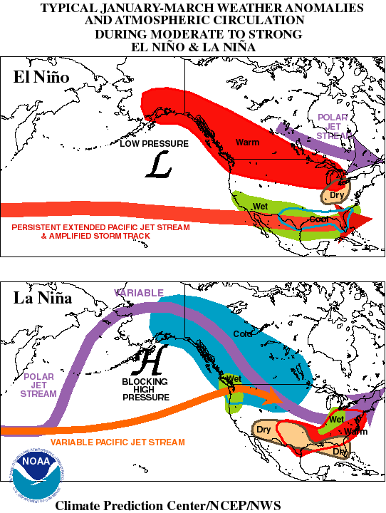
It's due to the "El Nino" weather pattern that we have been in since late last year. A moderate to strong El Nino typically creates cool days with more clouds and above average rain compared to a typical winter.
Here's a picture comparing El Nino to La Nina weather patterns:
http://celebrating200years.noaa.gov/magazine/enso/nawinter.gif
See you tonight at 5 and 6 on WINK-TV.
Jim
Mr. Farrell,
I am just wondering as to WHY the winter weather here in Ft. Myers has been so cold this year. This is very unusual. It is just one cold front after another. I am hoping you can give me some type of an explanation. Thank you.
Answer:
It's due to the "El Nino" weather pattern that we have been in since late last year. A moderate to strong El Nino typically creates cool days with more clouds and above average rain compared to a typical winter.
Here's a picture comparing El Nino to La Nina weather patterns:
http://celebrating200years.noaa.gov/magazine/enso/nawinter.gif
See you tonight at 5 and 6 on WINK-TV.
Jim
A cold afternoon in store! Our coolest high temperature ever on this date in Ft. Myers is 55 degrees and we're not going to be much warmer today!
Expect highs only in the mid to upper 50's this afternoon with pockets of low 60's possible inland. Add to the cold air, a cold wind with northerly wind at 15 mph with gusts to 25 mph and we'll be donning the coat all through the day!
And after a cold day, get ready for a very chilly night tonight! Expect lows in the low 40's along the coast to mid 30's inland with near freezing temperatures possible for inland parts of DeSoto and Charlotte counties. With a north wind remaining present at 5-10 mph through the overnight, wind chills in the 20's likely late tonight through early tomorrow morning.
Stay warm!
Lauren
Brian: Highest temps of day happening right now for most of us..
Morning everyone! Behind yesterday's cold front and the big winter storm cranking up off the east coast, cold air is funneling rapidly into southwest Florida. Temps this morning (right now, about 6 AM) are in the mid 50's north to the low 60's south.. these will likely be near the highest temps we'll see all day! Most of us stay in the 50's for highs this afternoon, even with plenty of sunshine. As low pressure really explodes east of the Mid Atlantic later today and high pressure builds in for us, the difference between the two systems will send strong northwesterly breezes toward SWFL... average wind will be near 20 mph with gusts to 30 mph possible. A rough day for you boaters, for sure!
More on the forecast on WINK.. by the way, moderate to heavy snow falling through much of DC and Baltimore.. briefly freezing rain now near Philly.. and snow in NYC. Yesterday's forecast totals are on the mark.. with about a foot expected in DC, 12 - 18" near Baltimore, 18 - 24" Philly and NYC... and 12 - 18" near Boston!
Brian
Tuesday, February 9, 2010
Cold is Coming, Again
Tomorrow afternoon will be the coldest day in about a month with high temperatures near 60 degees. A 20 mph wind will make it feel like the 50's all afternoon. More about the upcoming extended cold period at 11pm on WINK-TV. - Jim
Got a Question?
Question:
Hi Jim,
I need you to settle a friendly dispute between friends.
Re the weather the last few weeks with all the U.S. mid east storms, my friend says it is due to the warm, moist winds coming off the Pacific Ocean. Causes El Nino , etc.
I thought i heard you or Reif or one of our weather men on TV that it was due to the warm, moist winds coming out of the Gulf.
Is it from the Pacific or the Gulf of Mexico?
I need your expertise.
Thank you.
Answer:
I can give you an answer that makes you both right. In this El Nino Winter pattern Pacific Ocean moisture brings more rain to California, but it is the Gulf moisture that feeds the weather system that produces the snow in the NE US and the rain here in SW Florida.
--
Jim Farrell, CBM
Chief Meteorologist
WINK-TV
Ft. Myers, Fl. 33993
239-338-4368
Scott: Rain moving into the area now! Light rain with a few pockets of heavier rain. Probably see about .15" on average. Cold weather on the way..
Well the cold front will arrive tonight. We are see some light rain now with a few pockets of heavy rain offshore. Not a lot expected, about .15" on average. Behind the front, windy weather will arrive and much cooler days as well. Highs tomorrow will only get into the upper 50's. Lows Thursday morning will fall into the upper 30's through out most of SWFL. Another shot of rain and storms arrives Friday night! Much more expected then. However the weekend is looking a little better.. Stay tunned. see you at 7pm. Jim starts at 5pm with the details.
--
Scott Zedeker
WINK TV Meteorologist
--
Scott Zedeker
WINK TV Meteorologist
Brian: Rain approaching Sarasota County.. warm & windy elsewhere..
It's a warm afternoon with temps now in the mid to upper 70's, even with increasing clouds. Showers should begin to arrive over the next hour or two north of the Caloosahatchee and for the rest of the area late this afternoon. Expect showers to continue through around midnight tonight, with around a quarter inch of rain for most areas. Much cooler tomorrow with temps in the upper 50's to near 60.. even with a mostly sunny sky! Trend is toward another extended stretch of below average temps across the area, although this cold snap will not be nearly as severe as the one the first 2 weeks of January!
Brian
Brian: Rain moves in later today..

Rain is on the way later today as another cold front moves into the eastern Gulf of Mexico. We'll start the day partly cloudy but clouds will increase this afternoon and the rain arrives from north to south. Even with the clouds and chance of rain this afternoon, it will be much warmer today -- and breezier -- as temps push toward the mid 70's.
The front comes through late tonight and, in the end, we'll see around a quarter inch of rain through most of the area. By the time you wake up tomorrow morning, the sky will be clearing and cooler air will be moving in. In fact, with cold air filtering in througout the day tomorrow, temps will likely struggle to make it out of the upper 50's!
We'll get a bit warmer on Thursday with some clouds moving in ahead of our next system, highs in the mid to low 60's. By Friday, today's cold front will be moving just a bit farther north as a warm front -- it'll stay to our south though. That should give us a cool, raw, rainy day on Friday as low pressure moves along the old front over south Florida. The forecast models now have highs in the low to mid 60's for Friday; I'm going with a high of 61 and leaning cooler because of the stalled front to our south (rather than over us or to our north). It'll be interesting to see what the models do with temps on Friday over the next few days.. my guess is as a more southern track to our next low comes into focus, they'll start going lower.. I'm trying to stay ahead of that trend!
The next several days will continue to run cooler than average across the area. In fact, there are signs a new arctic front will move through on Monday! By the way, if you're interested in the big Ohio Valley/Great Lakes/Northeast snowstorm.. I put together a forecast snowfall accumulation map (never thought I'd do this in SWFL but it's been such an extraordinary winter for folks there and a lot of you are interested in the weather up north... so enjoy) above!
Brian
Monday, February 8, 2010
Rain Tomorrow, sorry kids
After a cool morning it will become cloudy and rain is expected by the afternoon and evening. I told my daughter that she may have to walk home from the bus stop in the rain. She wasn't happy, so I told her my school age life story about walking 1 mile to and from school, up and down hills in the Philadelphia winters in the snow with gloves and a ski mask on until my lips were so cold I couldn't talk for 20 minutes. She still thinks getting a little wet is terrible. Maybe that's why I never made the debate team. - Jim
Not As Cold
About 10 degrees milder tonight as a cold front approaches. Clouds and rain are likely tomorrow afternoon and evening. See you at 5:00 and 6, 7, 10 and 11! - Jim
Brian: Highs in the mid to upper 60's today.. mix of high clouds & sun
An active jet stream aloft is helping to bring in some high clouds from the next winter storm developing now over the mid and lower Mississippi River Valleys. I blogged about this snowstorm earlier and it's going to be another one that -- looking at our brand new forecast models -- will likely drop snow amounts that can be measured in FEET rather than inches in places like Baltimore and Philadelphia; and this time, more of that significant snowfall should make it up into southern New England.
Meantime, back at home, we'll see a warmer night tonight as our wind shifts around to the east and eventually southeast. We had lows in the 30's and 40's this morning; tomorrow morning, we'll be in the 40's and 50's. Clouds increase tomorrow ahead of the front, but it is breezy and warmer with highs pushing to the mid 70's. We'll see rain move through around sunset and into Tuesday evening, about a quarter inch of rain looks possible for most of the area. By the time you wake up on Wednesday morning, the rain is gone and cooler air is moving in... we'll struggle to get out of the low 60's for highs on Wednesday!
Next chance of rain gets here late Friday into Saturday.. and this one could bring over a half inch of rain to the area. The next several days look to feature temps below average as a series of fronts moves through!
Brian

Brian: Another major winter storm for the Mid Atlantic.. and New England this time
We have a good chance of showers in southwest Florida tomorrow afternoon and evening as a cold front comes through -- the latest in a series of fronts that have kept our winter abnormally cold across the area. Meantime, to our north, yet another major winter storm will impact the eastern part of the country... most notably in the northern Middle Atlantic and New England. This time, the storm track looks a little farther north so places like Washington, DC, and Baltimore will avoid the worst... while the heaviest snow this time looks to fall from near Philadelphia to NYC to south of Boston, MA.
Above is the GFS forecast model, the lower right hand panel is the accumulated liquid precipitation between now and Thursday afternoon. The yellow bullseye south of Philly indicates the possibility for more than 1.50" of precipitation... which could translate to well over a foot of snow once again. This winter, the models have generally put the heaviest snow bands a little too far south, following this trend it looks like the heaviest with this storm likely will fall closer to NYC. Bottom line: several places in the Northeast will have well over a foot of snow again later this week... with places farther north making up for lost time (Boston has only half the snow this winter of places like Philly, NYC, and Baltimore!).
What an amazing winter.. for them and for us.
Brian
Sunday, February 7, 2010
A chilly night ahead!
If you're out on the town celebrating the New Orleans Saints Super Bowl win then you're already of aware of that cool air! You'll need to layer on the winter coat as you head off to the workplace tomorrow morning as low temperatures settle into the mid 40's along the coast with upper 30's inland! A light north wind in the early morning hours will drop wind chills into the 30's even if the mercury has not!
A mostly sunny sky will breed a pleasant Monday afternoon as temperatures gradually warm to upper 60s along the coast to low 70s inland.
Bundle up tonight!
Lauren
A mostly sunny sky will breed a pleasant Monday afternoon as temperatures gradually warm to upper 60s along the coast to low 70s inland.
Bundle up tonight!
Lauren
Saturday, February 6, 2010
Cool and breezy tonight. Expect lows in the mid 50's along the coast to mid 40's inland. With a northwest wind at 10-15 mph, you will need the jacket if headed out late tonight or early tomorrow morning!
And you'll need to layer on that jacket or sweatshirt over the PJ's if you're staying up late or getting up early to observe Space Shuttle Endeavour lifting off from Cape Canaveral at 4:39 AM Sunday morning. Sky conditions will cooperate for a good view of the Shuttle's departure from Earth with a mostly clear to partly cloudy sky in place.
A few clouds possible mainly along the coast tomorrow morning otherwise plentiful sunshine is in store for Super Bowl Sunday! If you're planning on setting up the Super Bowl buffet on the lanai, you may be donning that Saints or Colts sweatshirt as you grab for the wings and chips with high temps only in the mid 60's tomorrow afternoon.
And if you're up late celebrating a win...be prepared for a chilly night with lows by Monday morning in the low to mid 40s.
Enjoy the game!
Lauren
Friday, February 5, 2010
Scott: Rain and a few storms moving thru SWFL now. Should pick up about .40". Sunny weather for the weekend, details at 5pm on WINK!
Rain ahead of the cold front is moving through the area. On average about .50" will have fallen all said and done. We have seen a few strong storms in our northern viewing area. No severe weather expected as this line of heavy rain weakens as it moves out of the region. For Saturday, clearing by the afternoon with highs only in the upper 60's. Super bowl Sunday is looking great. After a cool start we will see a sunny sky and temperatures in the upper 60's as well. Enjoy!
--
Scott Zedeker
WINK TV Meteorologist
--
Scott Zedeker
WINK TV Meteorologist
Expect scattered light to moderate showers to develop over the next couple of hours with warm temps near 80 degrees.
Mostly cloudy and windy with wind gusts near 30 mph this afternoon. A well-developed line of showers and thunderstorms preceding a cold front will push into SWFL early this evening with rain and thunderstorms continuing into tonight. A few storms may be strong with heavy rainfall, lightning, and gusty winds of 40+ mph possible. Rainfall amounts of .50" to .75" likely across the area with local amounts possibly exceeding 1.00" especially along Charlotte/Lee county coastline.
Rain comes to an end late tonight with a gradually clearing sky in store for Saturday. Cooler air on a northwesterly wind will continue to push in through the day tomorrow thus expect temperatures only in the 60's during the afternoon.
A chilly start to Superbowl Sunday with morning lows in the upper 40s and low 50s! Sunny conditions through Sunday afternoon with cool highs in the mid 60s.
Lauren
Windy then Wet
Windy today with rain on the way this evening. A cold front will pass through the area tonight and we will have cooler air in place by tomorrow. Clouds will leave in the midday and clear sky will be overhead by sunset tomorrow. Boaters: Sunday will have less wind than tomorrow. See you at 5 and 6pm on WINK - Jim
Brian: Warm & breezy this morning... rain arrives late this afternoon
Quick update here as we move through this morning's newscast: Temps starting in the 60's this morning and, even with clouds, we'll have no problems getting to near 80 degrees this afternoon. This morning, we're starting with a line of showers and storms across the central part of the Panhandle and this line, and associated cold front, will head in our direction later this afternoon. Arrival time for rain is close to 5 PM in Charlotte County and near or after sunset Lee/Collier Counties and inland. Some of the rain will be heavy with the possibility of more than a half inch (or even an inch!) of rain likely. Some of the storms could be strong given the arrival during or just after the greatest heating of the day... watch out for some strong wind gusts in any storms above 40 mph.
The rain's gone by daybreak tomorrow.. clouds will linger though as a west wind comes in off of the Gulf. Gradual clearing Saturday morning leading us into a cooler, but sunnier afternoon.. highs in the upper 60's. Mostly sunny for Super Bowl Sunday, with highs in the mid 60's.
Brian
PS Everything also on track for a huge snowstorm in the Mid Atlantic. Blizzard warnings are flying for parts of this area with heavy snow moving in later today and continuing through midday tomorrow. Snowfall totals near 2 feet possible in DC... 18" in Baltimore.. and a foot or more near Philly. Many travel cancellations already..
--
Brian Monahan
AM/Noon Meteorologist
WINK-TV
(239) 338-4369, brian.monahan@winktv.com
--
Brian Monahan
AM/Noon Meteorologist
WINK-TV
(239) 338-4369, brian.monahan@winktv.com
Thursday, February 4, 2010
Not as Cool Tonight
Temperatures will be about 10 degrees milder in the morning compared to the last morning. Wind and rain are still expected Friday, cooler Saturday.
Want to be an official Weather Spotter?
http://www.leeeoc.com/admin/Breaking%20News/2010%20SkyWarn%20Flyer%20Options.pdf
http://www.leeeoc.com/admin/Breaking%20News/2010SkyWarnCollier.pdf
- Jim
Want to be an official Weather Spotter?
http://www.leeeoc.com/admin/Breaking%20News/2010%20SkyWarn%20Flyer%20Options.pdf
http://www.leeeoc.com/admin/Breaking%20News/2010SkyWarnCollier.pdf
- Jim
Scott: Windy weather arrives Friday. Then the rain late in the afternoon. Could see a few storms as well. Read my blog for details!
Well the timing of this cold front will be around midnight Friday. However, the rain will start moving in by 5pm or 6pm. We could see about .50" to 1" of rain before we clear things out Saturday morning. The weekend is looking great! It will be on the cooler side. Highs are only expected to get into the upper 60's. Enjoy.
--
Scott Zedeker
WINK TV Meteorologist
--
Scott Zedeker
WINK TV Meteorologist
Breezy today, Windy tomorrow
A cold front will arrive tomorrow night, so tomorrow will be windy with increasing clouds and rain, a few thunderstorms will be possible. Boaters, a Small Craft Advisory will be in effect. See you at 5pm on WINK NEWS - Jim
Brian: Another huge snowstorm for the Mid Atlantic... major travel issues!

Every once in a while on this blog, we'll turn the focus away from Florida if something significant or notable is happening elsewhere in the country and you bet it is this weekend! Another major snowstorm is going to effect the northeast this weekend but, in what's been an unusual trend this winter, it's another snowstorm where the heaviest snow will fall across places like DC, Baltimore and Philadelphia rather than New York City -- and places like Hartford and Boston will end up seeing not much of any snow!
There's already been one historic snowstorm in the Mid Atlantic as just before Christmas places from DC to New York City were blanketed in a foot and a half to nearly three feet of snow. For the second time this winter, another 1-2'+ snowstorm will effect the very same areas. In the image I've included above, you're looking at the Eta model's forecast of total precipitation in inches between Thursday morning and Sunday. Notice that bright red stripe that extends from near Washington, DC to Cape May, NJ? That indicates the potential for over 3" of liquid precip!! This should fall as all snow.. and, assuming (and this is usually a safe assumption - the colder the air, the higher the ratio and vice versa) that 1" of rain translates to 10" of snow... the Eta model says nearly 2 1/2 feet of snow are possible in this area!
The reason for so much precip? A ton of Gulf moisture will be fed straight up the eastern seaboard into this storm (we'll feel the effects here with some heavy rain possible Friday night) and that will fall into some very cold air in the lowest 5,000 feet or so of the atmosphere across the DC to Philly areas. At the same time, warmer air will move in above this cold air (say around 10,000 feet) and that leads to rapidly rising air... which helps create heavy precipitation. It's already been a memorable winter in the Mid Atlantic and, with this next major storm, folks there are on their way to potentially an historic winter in terms of snowfall totals!
Brian
Brian: Cool start, warm finish today... rain forecast on track for tomorrow night!
We're starting this morning with temps in the 40's and 50's across southwest Florida. There will be some patchy fog/haze in a few spots to start the morning, but it will not hang around nearly as long as yesterday. Plan on a partly cloudy sky today with highs in the upper 70's for most of us. Tomorrow, clouds will increase late in the day in advance of our next cold front... it will be warm and breezy with highs pushing to around 80 degrees! I can't rule out a stray shower moving quickly from west to east tomorrow afternoon, but the main line of showers and storms waits until well after dark to arrive. There will be some heavy rain in a few spots as the front comes through Friday night/early Saturday.. right now, it looks like most of the area should see around a half inch of rain.
The front's through and the rain is gone by about daybreak Saturday, but we won't clear out fully behind the front! The wind will stay westerly Saturday afternoon, eventually turning northwest and north.. as long as it stays west and northwest, though, there should be some low clouds hanging around as cool air moves over the Gulf. Plan on clouds gradually decreasing Saturday. Sunday just some high clouds around and much cooler, with highs in the mid 60's! Super Bowl XLIV in Miami looks pretty good.. mostly clear sky with temps in the 60's at kickoff falling into the 50's by the 4th quarter.
Brian
Wednesday, February 3, 2010
Cooler
Look for a slightly cooler night with lows in the upper 40's inland. The sunshine will come earlier tomorrow with fewer early day clouds. Warmer by the afternoon. Details at 11 tonight on WINK in HD. - Jim
A Nice Evening
Clear Sky with temperatures in the 60's this evening, but a little colder tonight with some inland neighborhoods waling up to temperatures in the upper 40's. See you at 6pm on WINK-TV. - Jim
Scott: Slow clearing this morning, but we still got into the low 70's in many locations. Warmer tomorrow, and the next cold front arrives late Friday!
Another chilly night ahead, lows in the 50's. By Thursday afternoon we will see highs in the upper 70's and a few low 80's. Enjoy your Thursday. Next cold front arrives late Friday evening. We will see a line of showers and thunderstorms, could see a .50" to 1.00". Clearing by Saturday morning but it remains cool, highs in the upper 60's. Nice weather for your superbowl Sunday.
--
Scott Zedeker
WINK TV Meteorologist
--
Scott Zedeker
WINK TV Meteorologist
Clear and Cool
Clear sky and cool temperatures will be in place tonight. Look for a mostly sunny afternoon tomorrow with warmer temperatures as the wind shifts out of the southeast at 10 - 15 mph. - Jim
Brian: Cooler with low clouds this morning.. partly cloudy this afternoon
Starting out this morning with a lot of low clouds and some fog across the area, even with breezy weather. The reason? There is what we call a shallow inversion layer in place; a very small layer of the atmosphere where the temperature increases with height (unusual) over the lowest 1000 feet or so of the atmosphere. This is keeping some of the moisture left behind from yesterday's cold front trapped near the ground and giving us the low clouds. Gradually, though, this inversion will break enough to allow the clouds to fade out... by mid to late morning we should have a partly cloudy sky. It will be breezy & cooler today with temperatures in the upper 60's and low 70's.
Yesterday's cold front will return tomorrow as a warm front, giving us a few more clouds and warmer temperatures. The late week forecast is still on track.. a cold front gets here close to midnight Friday into early Saturday. Out ahead of it, it will be breezy and warm Friday with temps in the upper 70's and low 80's. Rain arrives very late Friday night and is with us through early Saturday morning. Partly cloudy and cooler Saturday PM and Sunday, with temps in the 60's!
Brian
Tuesday, February 2, 2010
Cooler
Temperatures will run about 10 degrees cooler by morning. Drier air
will help create conditions for sunshine in the afternoon. - Jim
will help create conditions for sunshine in the afternoon. - Jim
Scott: Rain ending across the area now! Over an 1" in many locations in Lee county. Sun returns tomorrow. Details at 5.
Cold front moving thru the area this evening. Ahead we saw anywhere from 1" to 1.50" of rain in coastal Lee County. Everybody else about .25" to .50". You can expect to see a lot more sun Wednesday as we will dry out with a northeasterly breeze 10 to 15 mph. Temperatures will stay in the low 70's and our overnight lows will fall into the low 50's Thursday morning. Next cold front arrives in the overnight period Friday into Saturday morning. Good news is that looks like the weekend is looking sunny and cool. Highs in the upper 60's, lows in the 50's. Details starting at 5pm on WINK.. By the way, Phil saw his shadow... Six more weeks of winter weather ahead!!
--
Scott Zedeker
WINK TV Meteorologist
--
Scott Zedeker
WINK TV Meteorologist
Rain Ending
Rain has ended in Charlotte, DeSoto and Highlands County. Rain is ending in Southern Lee County and will end in Collier and Henry Counties this evening. Next up, cooler nights and sunny days. Details on the next chance of rain on WINK NEWS at 5pm. - Jim
Cold Front
The cold front is near Tampa right now, so we are getting wet. Look for rainfall totals at 5pm on WINK. The rain will end this evening and the cooler air will arrive tonight. Yes, there will be sunshine tomorrow! - Jim
Brian: Rain moving onshore in Lee & Charlotte now...
Quick update: Rain is moving into coastal Lee & Charlotte Counties now in advance of a cold front that will bring brighter and drier weather to southwest Florida later today and tomorrow. Expect rain, some heavy, to move through the area between now and about 4 PM.. with slow clearing from west to east. Temps will fall from the 70's into the 60's most areas by sunset this evening. More coming up in about 7 minutes on WINK...
Brian
Brian: Phil sees his shadow, Mona doesn't..
Another Groundhog Day has arrived and we have the forecasts:
Mona - our own groundhog in southwest Florida - did not see her shadow this morning. Neither did Staten Island Chuck. Both furry forecasters have spring arriving early this year.
On the other hand, in Punxsutawney, PA, Phil did see his shadow meaning there will be six more weeks of winter. Not sure how this happened with clouds and snow nearby at the time of Phil's emergence! Seems like the fix is in! Or, maybe he saw his shadow because of thousands of camera flashes and TV lights.. who knows!
Brian
Brian: It's Groundhog Day! Will Mona and Phil see their shadows?
We're just a few minutes away from those famous weather prognosticators - groundhogs - emerging from their dens and making their yearly predictions. Most of the time (almost 100 times), Punxsutawney Phil in Pennsylvania sees his shadow -- meaning 6 more weeks of winter. Right now in Pennsylvania, there's lights now around and plenty of clouds.. so Phil should not see his shadow! It's the same story here in southwest Florida with plenty of clouds and showers in the Gulf of Mexico pushing onshore; Mona the Groundhog - at The Shell Factory in North Fort Myers - should also not see her shadow. What does this mean? An early end to winter and start of spring! We shall see..
For today, showers around through early afternoon ahead of a cold front. Clouds will decrease late and we should see some sun near sunset.. highs in the mid 70's. For tomorrow, partly cloudy and cooler - lows in the low to mid 50's and highs in the lower 70's.
Brian
Monday, February 1, 2010
Scott: A few showers left over through the evening and overnight. We will start to clear out late tomorrow. Better weather Wed.!
A warm front is passing overhead tonight. Might see a few showers from now through the overnight period. By tomorrow, early afternoon a cold front swings through giving us another chance of a rain. By the late afternoon the cold front will be south of SWFL and we should start to clear things out. Cooler weather by Wednesday but more sun in the forecast. Next big front arrives late friday into Saturday morning. The weekend is looking great! Details on WINK starts at 5 today..
--
Scott Zedeker
WINK TV Meteorologist
--
Scott Zedeker
WINK TV Meteorologist
Brian: Forecast on track... temps rising toward 70... rain moves north
Quick update: everything in line from this morning's forecast. The warm front is still way to our south, but should start moving north more quickly later today. This should allow temps to climb toward 70 later today in Lee and Collier Counties while we stay in the mid 60's north. Rain moves north as well; it's heaviest now in Lee, Collier and Hendry Counties.
Brian
Brian: Temps a tricky forecast today..
This is one of those hair-pulling kind of forecasts temperature-wise in southwest Florida! Our forecast models are all over the place on temps today with the forecast complicated by a warm front forecast to move across the area later today. We'll spend most of the day on the cooler north side of the warm front... that means showers and periods of rain in your forecast for today -- first south of the Caloosahatchee with rain overspreading communities north of the river through the morning. We could see over a half inch of rain for most of the area between this morning and tomorrow afternoon.
Right now, we have what's known as a strong low level inversion in place. Usually the temperature decreases with height but this morning temperatures just about 2500 feet above the ground are in the 60's while it's in the 50's at the ground. This low level inversion will remain stuck in place as long as we're on the north side of the warm front. The models differ on when and how far north the front gets today; one of our models has the warm front moving all the way to near Tampa by 7 PM tonight while others have it staying south of Naples most of the day! To make matters worse, some models have temps stuck in the mid 60's today while others take even Fort Myers into the mid 70's this afternoon!
Because high pressure is pretty strong over Florida and the front is fairly weak right now, I'm leaning toward the cool side of things today. That should keep most areas north of Collier County in the 60's this afternoon while Naples gets into the lower 70's later today (perhaps mid 70's). The front should be located in south Lee County by 5 pm tonight and move across the rest of the area overnight. Tonight will likely be one of those strange nights where temps are steady or even rise after sunset!
Brian
Subscribe to:
Posts (Atom)