Tuesday, August 31, 2010

Earl From Above


Hurricane Earl as seen from the ISS, International Space Station. Astronauts aboard the ISS have the best seat in the theater, but earthlings have better snacks and facilities. - Jim

Scott: Breezy again today as drier air pushes in. Earl still a cat 4 hurricane. Details on WINK

How about no rain in the forecast for the next coupls of days. Dry air from the west side of Earl will filter in on the east and northeast breeze.  This pattern will be in place unitl Friday and Saturday. Then we will have a little more moisture work back in as Earl moves into New England and Canada.
 
Earl is still a cat 4 hurricane and is starting to move more to the NW now. The east coast will still have to monitor this hurricane closely as it will pass dangerously close to the outer banks of the Carolinas. Most of the models keep Earl in the Atlantic. A trough of low pressure digging toward the east coast will cause Earl to move to the NE by Friday morning. The strength of this trough will determine if Earl stays in the Atlantic. The stronger the trough means Earl stays away from the east coast. That is what we are thinking. Just because Earl stays out in the Atlantic the east coast will still see higher tides with high surf and rip currents.
 
Fiona will have a hard time staying together by Friday. Tropical Storm Fiona will be on Earls heels and running into a lot of wind shear. Looks like no threat for anybody in the US..
 
Details on WINK now and join me at 7 pm on WINK. 

--
Scott Zedeker
WINK TV Meteorologist

Earl gets closer...

As Hurricane Earl gets closer to Florida it will help drive drier air over SW Florida. Tomorrow and Thusday could be very dry days thanks to Earl. Fiona may be too close to Earl to compete and strengthen for now. Enjoy a break in the rainy weather. - Jim

Brian: Isolated rain today, breezy with highs in the lower 90's...

Good morning! Dry air continues to push toward southwest Florida today, although a little more slowly than I was anticipating yesterday. As a result, I've returned the chance of a few isolated showers/storms to the forecast for today. By tomorrow though, the dry air you see on the above image (precipitable water, blue color north of FL indicates really dry air) will become fully entrenched and we should be able to cut off the chance of rain altogether for Wednesday and Thursday.
 
Today's forecast:

Naples  Partly Cloudy  Isolated PM Rain; High 91
Bonita Springs Partly Cloudy  Isolated PM Rain; High 92
Fort Myers Partly Cloudy  Isolated PM Rain; High 92
Cape Coral Partly Cloudy  Isolated PM Rain; High 92
Port Charlotte Partly Cloudy  Isolated PM Rain; High 92
Hendry Co. Partly Cloudy  Isolated PM Rain; High 90
Glades Co. Partly Cloudy  Isolated PM Rain; High 90 
DeSoto Co. Partly Cloudy  Isolated PM Rain; High 91
 
Have a great day!
 
Brian

Brian: Earl a major Category 4 hurricane.. wind 135 mph.. Fiona minimal TS.. wind 40 mph..


Monday, August 30, 2010

Scattered Rain and a Hurricane

Hurricane Earl is a Cat 4, likely to become a Cat 5. Earl will bring a shot of drier air to SW Florida Wednesday and Thursday. It might even feel a little less humid! Fiona is a Tropical Storm, but I don't see Fiona affecting our weather much. Oh yea, there might be a NE breeze in SW Florida tomorrow, Wed and Thurs from Earl. - Jim

Brian: Earl not a concern for Florida, but what about Invest 97L?

Good afternoon! This morning, Hurricane Earl was upgraded to a major Category 3 storm with wind at 120 mph. Over the coming days, Earl is expected to increase in intensity -- likely becoming a Category 4 storm. For now, Earl is moving to the west-northwest and, with Earl now battering the Virgin Islands and Puerto Rico -- if this motion were to continue, Earl would be a storm we'd be concerned with here in southwest Florida. But, we're not. Why?
 
A weakness in the subtropical ridge across the western Atlantic, created in part by Hurricane Danielle, will allow Earl to begin rounding the western periphery of the high and turning more toward the northwest over the next day. This will allow Earl to pass several hundred miles to the east of southwest Florida, providing us with dry and breezy weather. However, Earl could get perilously close to the Carolinas or the Northeast coast by the end of the week.
 
For now, a strong high is centered over the Northeast; this high is expected to weaken and kick to the northeast over the next few days as Earl moves northwestward. If this high is slower to break down, Earl will likely get pushed farther west and could approach the Cape Hatteras, NC. If the ridge breaks down a little faster, but not fast enough, Earl could get drawn west a little farther up the coast and be a significant concern for eastern New England by Friday and Saturday. Either way, Earl will bring high surf and wind to the east coast from the Carolinas northward. At this point, though, it does appear that the high will weaken fast enough for Earl to get picked up by a trough of low pressure moving through the Great Lakes late this week. This will push Earl just to the east of the northeast coast.
 
Invest 97L
 
There is a large, well organized tropical wave located in the central Atlantic, east of Earl. This wave has been competing some with Earl's circulation (and losing) and some wind shear. Thus far, while close, this wave has not been upgraded to a tropical depression. As this system tracks westward, it will be worth watching as our models have shifted back and forth as to where its headed -- yesterday's runs brought it close to the southeastern US while today's runs take it out to sea along with Earl. Stay tuned!
 
Brian

Brian: Earl is now a major Category 3 hurricane... likely to pass just east of the US East Coast...


Brian: Earl strengthens a little more as of 8 AM... now a powerful Category 2 storm/110 mph.. near Virgin Islands


Brian: Next tropical depression could form in central Atlantic later today.. east of Earl..


Brian: Drier air moving into SWFL today, scattered storms today... mainly dry rest of week..

Good morning! Today will be the transition day toward an unusually dry late August/early September week across southwest Florida. As high pressure builds southward across the peninsula, expect enough moisture to be around for scattered showers and storms this afternoon -- especially south. By tomorrow, as that high becomes anchored across the area and Hurricane Earl begins moving to our east, dry air will be reinforced leading to partly to mostly sunny sky Tuesday through Friday. Hot weather expected, though, with aternoon highs climbing toward the mid 90's at mid week.
 
Today's outlook:
 
Naples  Partly Cloudy  Scattered PM Storms; High 91
Bonita Springs Partly Cloudy  Scattered PM Storms; High 91
Fort Myers Partly Cloudy  Isolated PM Storms; High 91
Cape Coral Partly Cloudy  Isolated PM Storms; High 91
Port Charlotte Partly Cloudy  Isolated PM Storms; High 92
Hendry Co. Partly Cloudy  Scattered PM Storms; High 90
Glades Co. Partly Cloudy  Isolated PM Storms; High 90
DeSoto Co. Partly Cloudy  Isolated PM Storms; High 91
 
Have a great day!
 
Brian

Brian: Earl now a 105 mph Category 2 hurricane... near Virgin Islands... will approach US East Coast....


Friday, August 27, 2010

Scott: Storms growing across SWFL! Slowly drifting toward the coast now. Plus Danielle now a cat 4 hurricane.

We are watching slow moving storms developing across the area now. Weak steering currents will stay in place thru tonight. By tomorrow storms will be moving in from the east. You can expect morning sun with afternoon storms in the weekend forecast.
 
First major hurricane of the season has formed this morning at 5 am. Danielle is a cat 4 hurricane with wind at 135mph. No threat on the USA. Tropical Storm Earl is still trying to organize. Either way looks like it will stay out in the Atlantic too. Another wave off the coast of Africa that will develop early next week will also follow Earl and Danielle. Reason for this motion is an east coast trough is weakening the Bermuda high. This will allow these systems to turn to the north along the western side of the high. Good news for us in the USA.
 
Enjoy your weekend!

--
Scott Zedeker
WINK TV Meteorologist

Scott: Storms growing across SWFL! Slowlt drifting toward the coast now. Radar updates on WINK now. First major hurricane of the season forms.

We are watching slow moving storms developing across the area now. Weak steering currents will stay in place thru tonight. By tomorrow storms will be moving in from the east. You can expect morning sun with afternoon storms in the weekend forecast.
 
First major hurricane of the season has formed this morning at 5 am. Danielle is a cat 4 hurricane with wind at 135mph. No threat on the USA. Tropical Storm Earl is still trying to organize. Either way looks like it will stay out in the Atlantic too. Another wave off the coast of Africa that will develop early next week will also follow Earl and Danielle. Reason for this motion is an east coast trough is weakening the Bermuda high. This will allow these systems to turn to the north along the western side of the high. Good news for us in the USA.
 
Enjoy your weekend!

--
Scott Zedeker
WINK TV Meteorologist

Danielle Becomes First Major Hurricane of the Season

At 11pm last night Hurricane Danielle remained at Category 2 status, but with very warm water beneath and low wind shear above the system, Danielle rapidly strengthened into the first major hurricane of the 2010 season overnight. As of the 5am advisory from the National Hurricane Center, Hurricane Danielle is a Category 4 storm with winds of 135 mph.
Forecast models continue to indicate that Danielle will remain over Atlantic waters and will not threaten the United States though swells from Danielle will begin to affect the U.S. East Coast by the weekend and will likely cause dangerous rip currents. One Category 4 Hurricane developed in 2009, Hurricane Bill formed in mid August with winds of 135 mph at it's strongest. Bill made landfall in the Canadian province of Newfoundland as a tropical storm.

Tropical Storm Earl remains a 45 mph tropical storm positioned in the central Atlantic. Models are indicating that Earl will continue on a westerly track for the next few days but will begin to make a northerly turn as the system approaches the Lesser Antilles. Earl may intensify into a hurricane over the weekend.

And a strong tropical wave in the far eastern Atlantic may develop into our next tropical depression within the next few days. The next complete advisory from the National Hurricane Center will be issued at 11am and I'll have the latest on WINK News Now at 11am on 6TV.

Have a good day,
Lauren

Thursday, August 26, 2010

Scott: Storms moving into coastal Collier now. Radar at 7 on WINK. Still two systems in the Atlantic also.

A few showers and storms heading into coastal Collier county now. Join me at 7 for radar updates.
 
Tropics are still active TS Earl still on a westerly track in the central Atlantic and Danielle now a cat 2 hurricane heading northwest. Danielle will not effect the USA. Earl...? Still need to watch this one. Most models turn it northward by days 4 and 5. Stay tuned.
 
Another wave coming off the African coast. This will be following Earl. This could become the next named storm in the coming days.

--
Scott Zedeker
WINK TV Meteorologist

Brian: African wave train lining up as we approach the peak of the Atlantic season

Good morning! Wow, have things changed in the tropical Atlantic Ocean since we passed August 20. Why August 20 you might ask? This date is typically the date where tropical activity begins to spike in the Atlantic basin, a spike that lasts through September and (in a season like this one is expected to be) into October. This morning, we have two active tropical cyclones, a large tropical wave moving off the west coast of Africa, and at least 2 or 3 new waves building across equatorial Africa. It promises to be very busy in the coming days!
 
Hurricane Danielle
 
Danielle is now a strong category 2 hurricane, with wind back to 105 mph -- the strongest it has been during its history. Over the last few hours though, the convection has died down on satellite imagery, and Danielle may be feeling the effects of some stronger wind shear on its northern side -- which may be allowing drier air to become entrained in the cyclone (similar to a couple of days ago). Danielle is now being tugged northwest by a trough of low pressure to its north, but it will move back underneath a high later today and could turn back toward the WNW before ultimately curving away from the United States.
 
Danielle may bring tropical storm conditions (at least) to Bermuda this weekend as well as high seas to the east coast. It won't affect our weather (if anything, it will actually help bring drier weather to the area as it forces sinking air on its western side into south Florida after the weekend). I don't see why Danielle won't be picked up by the east coast trough and carried out to sea. I should note, though, that there is a little more spread in our models this morning -- with a few allowing Danielle to linger off the east coast most of next week as the trough leaves it behind. Right now, I think this is very unlikely.
 
Tropical Storm Earl
 
Earl is located about 3100 miles from SWFL this morning in the eastern Atlantic. Likely feeling the effects of sinking air on the eastern side of Danielle plus the upwelling of cooler water from below by Danielle, Earl is unlikely to develop nearly as fast as Danielle did. Earl is also starting at a farther south latitude than Danielle, so a more westerly track for a longer period of time is likely. Earl is forecast to become a hurricane in a couple of days; I think the models may be too fast to do this because of the close proximity of Danielle.
 
Down the line, most of our models hint that Earl will follow a similar (but slightly more westerly) path compared to Danielle. A couple of points, though: if the break in the high pressure over the western Atlantic fills in behind Danielle -- Earl would have a chance to come back even more to the west. Also, a weaker Earl would feel the northward tug of Danielle less, allowing it to track more westerly. The bottom line with Earl is that, unlike Danielle, its path definitively away from SWFL is not a "done deal." Earl is worth watching over the next few days.
 
African Wave Train
 
A strong tropical wave has moved off the west coast of Africa today and may slowly develop (or become dominant compared to Earl) as it moves westward. A couple of our models put this wave in the Caribbean over Labor Day weekend while others squash it and don't develop it. There are also several other waves headed west across Africa, all worth watching as they approach the Atlantic
 
Brian

Brian: Heavier showers pushing out of Collier and into east Lee County...

The heavier rain that has been affecting parts of Collier County this morning is beginning to move into Lee County -- with heavier showers now being reported across the south side of Lehigh Acres. Elsewhere, there are a lot of clouds around this morning and isolated pockets of light rain/drizzle. Our mid level moisture continues to team with a stalled frontal boundary across the southeast today to yield a mostly cloudy day with showers and storms likely both in the morning and in the afternoon. With the clouds and rain around, highs will fail to reach 90 degrees for much of the area for a 5th straight day.
 
By the weekend, I think we'll be able to remove the chance of morning rain as the steering flow becomes northeasterly around a strong ridge of high pressure that will build across the eastern part of the country. But on the south side of that ridge, low level moisture will still be locked in place over SWFL leading to numerous afternoon showers and storms, especially on Sunday. Finally, drier weather should build into the area starting Monday!
 
Today's forecast:

Naples  Mostly Cloudy  AM & PM Storms; High 87
Bonita Springs Mostly Cloudy  AM & PM Storms; High 87
Fort Myers Mostly Cloudy  AM & PM Storms; High 88
Cape Coral Mostly Cloudy  AM & PM Storms; High 88 
Port Charlotte Mostly Cloudy  AM & PM Storms; High 88
Hendry Co. Mostly Cloudy  AM & PM Storms; High 88
Glades Co. Mostly Cloudy  AM & PM Storms; High 89
DeSoto Co. Mostly Cloudy  AM & PM Storms; High 89
 
Stay dry!
 
Brian

Brian: 2"+ of rain already this morning near Golden Gate.. more heavy rain falling now...


Brian: As of 5 AM, both Earl & Danielle a little stronger... watching another wave east of Earl...


Wednesday, August 25, 2010

Scott: rain ending across northern areas, however developing in Collier Co. TS Earl has formed. Details @7 on WINK.

Still a little wet in the morning as well as the afternoon for the next few days. The sun will make a return by the weekend. looks like a more normal pattern sets up by Saturday and Sunday!
 
Tropical storm Earl has formed in the eastern Atlantic. Wind is at 40 mph and it is moving to the west at 18 mph. Long range models show a westerly track until days 4 and 5 when a slight turn to the north happens. I am pretty confident that Earl will be following on the heals of Danielle into the northern Atlantic, not threatening the east coast.

--
Scott Zedeker
WINK TV Meteorologist

Tropical Depression #7 Forms in the Eastern Atlantic

As Brian indicated would occur in his earlier blog, the National Hurricane Center, in their 11am advisory, declared the tropical wave off the west coast of Africa in the far Eastern Atlantic to be the seventh tropical cyclone of the season. Tropical Depression #7 has winds of 35 mph and remains in an environment of low wind shear and very warm water...thus TD #7 will likely become Tropical Storm Earl later today or tomorrow morning.

Hurricane Danielle continues to churn in the central Atlantic as an 85 mph category one hurricane. Models continue to indicate that Danielle will not pose a threat the United States but may closely approach Bermuda early next week.

The next advisory from the National Hurricane Center regarding Hurricane Danielle and TD #7 will be issued at 5pm today and Meteorologist Scott Zedeker will have the latest on WINK News Now coming up at 5pm.

Have a good day,
Lauren


Brian: TD 7 forming in eastern Atlantic... advisories likely to start later this morning per NHC...

Earlier today, I was wondering why the NHC hadn't yet classified the large wave east of Danielle (and a bit south) as a tropical depression -- wonder no longer. As of their 8 AM tropical weather outlook, NHC is now saying advisories will likely be initiated on a new tropical depression in the Atlantic later this morning. So the bevy of activity in the tropical Atlantic expected this season appears to be underway, with two storms likely going in the basin by later today. There could be a third by the end of the week or this weekend as watch the next strong tropical wave coming off of the west coast of Africa. More coming later..
 
Brian

Brian: Light showers around SWFL this morning.. heavier rain later today..

Good morning! The clouds and rain stick around for a fourth straight day today with mostly cloudy sky and morning/afternoon showers and storms likely. Expect the cloudier than average weather pattern to more or less stay in place through the end of this weekend with only slightly drier weather for Thursday and Friday. By the end of the weekend, though, strong upper level high pressure nosing into the eastern part of the country should be able to send much drier air in our direction leaving us with just isolated storms early next week. Much more coming later!
 
First, today's forecast:

Naples  Mostly Cloudy  Scattered Storms; High 89
Bonita Springs Mostly Cloudy  Scattered Storms; High 89
Fort Myers Mostly Cloudy  Scattered Storms; High 88
Cape Coral Mostly Cloudy  Scattered Storms; High 88 
Port Charlotte Mostly Cloudy  Scattered Storms; High 88
Hendry Co. Mostly Cloudy  Scattered Storms; High 90
Glades Co. Mostly Cloudy  Scattered Storms; High 88
DeSoto Co. Mostly Cloudy  Scattered Storms; High 87
 
Brian

Brian: Danielle restrengthening in central Atlantic... wind back to 85 mph as of 5 AM...


Tuesday, August 24, 2010

Still Raining

Anyone know a place to get a nice Rubber Tree? This is the wettest 3 day period of the summer, so far. Abundant tropical moisture along with a weak Low Pressure to our west are still combining to deliver heavy rain. Rain is likely again tomorrow and just when we should be drying out a new trough of low pressure will be close enough to give us more rain this weekend. Details tonight on WINK NEWS. - Jim

Brian: A few heavier areas of rain moving through Lee County... less rain overall today...

As the above radar image shows, as of 11:30 am it's much drier today over southwest Florida than yesterday. A few heavier showers and storms will move out of the Gulf and push northeast through the day today (especially north of the Caloosahatchee), but overall expect less rain today. The heaviest activity is along a trough of low pressure that has been nudged ever so slightly northward today toward the Tampa-Orlando area. We still have a chance of both morning and afternoon rain tomorrow. After that, expect a bit more sun for Thursday and Friday with mainly afternoon storms in the forecast.
 
Brian

Brian: Wind shear/dry air interferes with Danielle... for now

Somewhat unexpectedly, Danielle has become less organized over the last few hours due to northwesterly wind shear tilting the storm somewhat, thus allowing dry air to move in from the west. Once the wind shear abates some, expected to happen over the next day or so, the strengthening of Danielle should resume and it still very well could become a major hurricane as it moves toward the general vicinity of Bermuda.
 
I attached above the water vapor image (notice the blacks/reds west of Danielle -- very dry air).
 
Brian

Brian: Dry air interfering with Danielle for the time being... back down to 80 mph @ 11 AM...


Brian: TD7/Earl could form in eastern Atlantic later today...


Brian: Isolated showers around SWFL... highs today in the mid to upper 80's...

Still not much rain out there now with only isolated pockets of light rain and drizzle around. Expect mostly cloudy sky today with highs averaging in the 80's -- with sun, some places could reach 90 degrees. A little warmer still toward the end of the week as deep moisture remains locked over northern and central Florida. By the weekend, as high pressure builds down the east coast, I expect the deepest moisture to work back to the south again and give us more clouds/higher rain chances Saturday and especially Sunday.
 
Brian

Brian: Why so wet? Blame the NAO...

Any time the blue lines extend below the 0 line on the graph above, something known as the North Atlantic Oscillation is in a negative phase. Essentially, this means the pressure difference between the Azores Islands and Iceland is very small and the upper level pattern, as a result, is likely very "congested" or blocked. This is the case this morning as high pressure sits across the central United States and over the NW Atlantic Ocean. What this is doing is locking low pressure in place over the Mid Atlantic and keeping our weather very unsettled in southwest Florida.
 
Brian

Brian: Isolated showers around this morning, not as much rain today...

Good morning! A weak ridge of high pressure is starting to inch northward from the Florida Straits and this should help nudge the highest chances of rain today toward central and northern Florida. That said, we can still expect a mostly cloudy sky and pretty good rain chances through much of the area, especially north of the Caloosahatchee. Clouds and showers should limit highs to the mid to upper 80's most places, expect for low 90's deep inland and south. That band of moisture will sit across the northern half of Florida through the rest of the week before shifting south again for the weekend. I'll have more coming up on WINK in just minutes!
 
Today's forecast:
 
TICKER
Naples  Clouds & Sun  Isolated Storms; High 90
Bonita Springs Clouds & Sun  Isolated Storms; High 90
Fort Myers Mostly Cloudy  Scattered Storms; High 87
Cape Coral Mostly Cloudy  Scattered Storms; High 87
Port Charlotte Mostly Cloudy  Scattered Storms; High 87
Hendry Co. Clouds & Sun  Isolated Storms; High 91
Glades Co. Clouds & Sun  Scattered Storms; High 90
DeSoto Co. Mostly Cloudy  Scattered Storms; High 88
 
Have a great Tuesday!
 
Brian

Brian: Danielle now category 2 hurricane... 100 mph wind...


Monday, August 23, 2010

Danielle and Rain


Danielle became a hurricane today. While Danielle should not come our way, it may become the seasons first major hurricane. Meanwhile, back at the beach, it's wet. 1"-4" of rain fell today and another 1"-4" is possible between now and Wednesday afternoon. The trough of low pressure to our north should retreat in a day or two allowing us to return to a more normal weather pattern by Friday. - Jim

Scott: A soggy start to the week. Up to 3.50" on Sanibel. More to come tomorrow? Details on WINK now! Danielle now a hurricane..

Two days of rain across swfl. Some areas picking up as much as 4"-5" since Sunday. Looks like the upper low and weak cold front that has caused all the wet weather will start lifting out of the area by tomorrow and Wednesday. Should still see some wet weather tomorrow, 1"-3" possible in some locations. But by Thursday, we will be back into a regular rainy season pattern.
 
Hurricane Danielle forms in the Atlantic. Category one hurricane moving to the WNW at 17 mph with wind at 75 mph. Either way no impacts on swfl or the USA. Its our second hurricane of the tropical Atlantic season.

--
Scott Zedeker
WINK TV Meteorologist

Brian: Heavy rain continues to fall in parts of coastal Lee/Charlotte/Collier...

Good morning! Our wet day, at least along the coast, continues with temperatures in the upper 70's and pockets of heavy rain mainly along and west of I-75. Expect clouds along with areas of heavy rain to continue -- and spread inland -- through the balance of the day. This will hold temperatures down into the mid 80's through most of southwest Florida. Some rainfall totals so far:
 
Fort Myers (WINK)  1.46"
Whiskey Creek  1.86"
Cape Coral  1.00"
Sanibel  1.50"
Fort Myers (Page Field)  .98"
Pine Island  .78"
 
Expect only slightly drier weather for tomorrow. In fact, much of the next week will average wetter than normal. More coming up on WINK and 6 TV!
 
Brian

Brian: Danielle a strengthening 60 mph tropical storm in central Atlantic

Good morning! Tropical Storm Danielle is a 60 mph tropical storm this morning located about 3000 miles away from southwest Florida in the open waters of the central Atlantic. What began as a tropical depression on Saturday was upgraded to a storm yesterday and, perhaps as early as tonight, could become the second hurricane of the Atlantic season (and, down the line, possibly the first major hurricane of the season).
 
Danielle is currently feeling the effects of some strong easterly wind shear; all day yesterday, the center of circulation was located on the eastern side of the deepest convection. This morning's initial visible satellite images reveal a center that may be more tucked under the deep convection. If this is the case, that would likely allow for additional strengthening over the next several hours and a quicker transition to a hurricane. Either way, wind shear is expected to weaken as the storm moves west-northwest over the coming days and Danielle becoming a hurricane is virtually assured.
 
The steering flow right now remains dominated by a ridge of high pressure located across the Atlantic. This ridge does have a break in it just north of Danielle and this is why the storm moved northwest for a time yesterday. This weakness in the ridge is expected to fill and a general WNW track can be expected for the next few days. Beyond that, the strong trough of low pressure along the east coast now is expected to break the western periphery of the ridge enough to allow Danielle to turn northwest toward Bermuda by late week. In all likelihood, Danielle will be picked up by this trough and carried east of the United States although a few more of the "wild" model scenarios actually have Danielle turning back toward the west once it reaches the latitude of Bermuda and potentially affecting the northeast coast late next weekend/early next week. This seems exceedingly unlikely. The good news is, though, we do not expect Danielle to affect our weather at all in southwest Florida.
 
Elsewhere, I'm still watching the potential over the next 7 days for a tropical system to form in either the Gulf or the Atlantic along the stalled frontal boundary/trough over the southeast. Either way, our weather will be a bit unsettled over the next several days -- with wetter and cloudier than average conditions expected. It is also quite possible that a new tropical wave that is just moving off the west coast of Africa will also develop into a tropical cyclone over the next 2-4 days. However, its strength will be dictated largely by what happens with Danielle -- given the close proximity to Danielle, the stronger Danielle gets the less likely it is that this new ave will become a very significant system. It will be worth watching though!
 
Brian

Brian: Heavy rain moving through Englewood.. more showers/storms developing elsewhere...


Brian: Heavy rain moving through SE Cape... Lee Island Coast... 1-2" in spots last hour or two...

Heavy rain is moving through Sanibel and Pine Island and now into the eastern side of Cape Coral. So far, these showers and storms have had a history of producing an inch or two of rain over the last couple of hours through South Fort Myers and Fort Myers. Now, the heaviest activity has shifted west of the Caloosahatchee into the Cape.
 
Elsewhere, the activity is more isolated in Charlotte County and even moreso in Collier County. Showers and storms, though, will continue to develop in the Gulf of Mexico and push onshore.
 
Today's outlook:

Naples  AM & PM Storms; High 90
Bonita Springs AM & PM Storms; High 89
Fort Myers AM & PM Storms; High 88
Cape Coral AM & PM Storms; High 88
Port Charlotte AM & PM Storms; High 88
Hendry Co. AM & PM Storms; High 90
Glades Co. AM & PM Storms; High 89
DeSoto Co. AM & PM Storms; High 89
 
Stay dry!
 
Brian

Brian: Heavy rain continues to fall in south Fort Myers/Fort Myers.. along & just east/south of River...


Brian: Areas of heavy rain affecting coastal Lee & Charlotte this morning...

Good morning! An upper level trough plus surface low pressure stretching from the eastern Gulf into the western Atlantic are teaming together this morning to give us a southwesterly steering flow. That along with plenty of moisture is helping to produce quite a bit of rain already out in the Gulf and some of these showers are already pushing onshore in Lee and Charlotte Counties. Expect another mainly cloudy day today with showers and storms possible anywhere at any time. It should turn a bit drier (but not much) tomorrow into Wednesday. I'll have much more on your forecast starting in 5 on WINK!
 
Brian

Brian: Danielle strengthens in central Atlantic... 60 mph TS, 3000 miles from SWFL...

The general forecast idea with Danielle continues to be that it's essentially no threat to the United States. More coming later.
 
Brian

Sunday, August 22, 2010

Tropical Depression #6 Becomes Tropical Storm Danielle

DEPRESSION BECOMES FOURTH TROPICAL STORM OF THE SEASON...


SUMMARY OF 500 PM AST...2100 UTC...INFORMATION
----------------------------------------------
LOCATION...13.4N 35.1W
ABOUT 725 MI...1165 KM W OF THE SOUTHERNMOST CAPE VERDE ISLANDS
MAXIMUM SUSTAINED WINDS...40 MPH...65 KM/HR
PRESENT MOVEMENT...NW OR 310 DEGREES AT 12 MPH...19 KM/HR
MINIMUM CENTRAL PRESSURE...1005 MB...29.68 INCHES


WATCHES AND WARNINGS
--------------------
THERE ARE NO COASTAL WATCHES OR WARNINGS IN EFFECT.


DISCUSSION AND 48-HOUR OUTLOOK
------------------------------
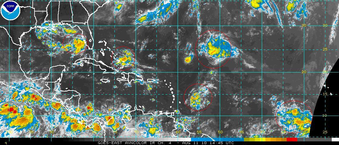
RECENT SATELLITE IMAGES INDICATE THAT THE DEPRESSION OVER THE
EASTERN ATLANTIC HAS STRENGTHENED INTO TROPICAL STORM DANIELLE.

AT 500 PM AST...2100 UTC...THE CENTER OF TROPICAL STORM DANIELLE WAS
LOCATED NEAR LATITUDE 13.4 NORTH...LONGITUDE 35.1 WEST.  DANIELLE IS
MOVING TOWARD THE NORTHWEST NEAR 12 MPH...19 KM/HR.  A TURN TOWARD
THE WEST-NORTHWEST WITH AN INCREASE IN FORWARD SPEED IS EXPECTED
LATER TONIGHT.

MAXIMUM SUSTAINED WINDS HAVE INCREASED TO NEAR 40 MPH...65
KM/HR...WITH HIGHER GUSTS.  ADDITIONAL STRENGTHENING IS FORECAST
DURING THE NEXT 48 HOURS...AND DANIELLE COULD BE NEAR HURRICANE
INTENSITY BY LATE TUESDAY.

TROPICAL STORM FORCE WINDS EXTEND OUTWARD UP TO 50 MILES...85 KM
FROM THE CENTER.

ESTIMATED MINIMUM CENTRAL PRESSURE IS 1005 MB...29.68 INCHES.


I'll discuss the latest details regarding the newest named storm of the season on WINK News coming up at 6:30pm.

Lauren


Friday, August 20, 2010

Weekend Weather Pattern

Showers and thunderstorms will have no choice. Since steering currents (the air that pushes the clouds around) are weak and expected to be weak through the weekend, rain areas will be moving slooooooooooooooly. Most of the rain should wait until after 12 noon. A tropical wave may become a tropical depression before the weekend is over, but look where it is. 11N, 27W.....way out there, for now. - Jim

Brian: Eastern Atlantic Tropical Wave Finally Organizing.. Watching Southeast US/Gulf Waters as Well...

Good morning! Today is August 20, which marks the tradition rapid uptick in activity in the Atlantic basin. Seemingly right on cue, it appears we will soon have our first Cape Verde (east Atlantic/west coast of Africa) system of the season. This will emerge from the cluster of storms stretching over quite a bit of latitude in the eastern Atlantic; it appears one of the clusters of storms is becoming dominant which will allow it to develop further -- especially as it starts to move slightly farther north and breaks free of the Intertropical Convergence Zone (ITCZ).
 
Most of our forecast models develop this system into a tropical cyclone by the end of the weekend and move it on a west-northwest heading toward the central Atlantic by the middle of next week. The amount of latitude this system gains as it moves north will be critical in determining its ultimate fate. At this point, essentially every one of our forecast models recurves this system will east of the United States as multiple troughs of low pressure prevent the subtropical high from strengthening sufficiently to keep the system on a westerly track. I will caution, though, that these early model forecasts -- without a true center of circulation -- and many days away from these low pressure troughs emerging off the US east coast should be taken with a grain of salt. This should be our first long-tracked system of the year and is worth watching over the next several days, but at this point, no forecast models indicate a threat to the United States. As long as enough of the dry air out ahead of it erodes over the next few days, conditions should be optimal for strengthening and some of the first hurricane model guidance coming out this morning takes this to a strong hurricane 5 days from now in the central Atlantic.
 
Elsewhere, things are relatively quiet as the tropical wave we were looking at in the Caribbean pushes onshore in Central America. Low pressure aloft will develop in the Gulf of Mexico or off the east coast of Florida this weekend and early next week as an upper level front/surface trough moves into the southeast. Often, this time of year, these areas can spawn what we call "home brew" tropical systems -- systems that start as extratropical and become tropical. A similar situation occurred when Tropical Depression 5 developed. So, don't be surprised if something does spin up along this frontal system in the southeast or in the Gulf over the next 3 or 4 days, starting tomorrow.
 
Have a great weekend!
 
Brian

Brian: Tropical wave becoming better organized near Cape Verde islands...


Brian: A few showers over Pine Island, Pine Island Sound, and Sanibel this morning...


Brian: Isolated showers along Lee and Charlotte coasts this morning...

Good morning! Humid, unstable air out across the Gulf and a light southerly steering flow are helping to guide a few showers northward along the Lee Island Coast and Cape Haze peninsula this morning. Inland, it's clear and we'll start sunny this morning. Expect another hot day with highs again climbing into the middle 90's. There will be a few more storms around this afternoon, but most of these will be inland. A better chance of rain overall moves into the forecast for Saturday and especially Sunday; more on this coming up on WINK at 5:15. Hope you can join us!
 
Today's forecast:

Naples  Partly Cloudy  Isolated PM Storms; High 93
Bonita Springs Partly Cloudy  Isolated PM Storms; High 94
Fort Myers Partly Cloudy  Isolated PM Storms; High 95
Cape Coral Partly Cloudy  Isolated PM Storms; High 94
Port Charlotte Partly Cloudy  Isolated PM Storms; High 95
Hendry Co. Partly Cloudy  Scattered PM Storms; High 95
Glades Co. Partly Cloudy  Scattered PM Storms; High 94
DeSoto Co. Partly Cloudy  Scattered PM Storms; High 93
 
Have a great day.
 
Brian

Thursday, August 19, 2010

Nice way to end the day

Thany you Russ from Cape Coral! Quite a shot.

Thunderstorms Fading, Tropical Wave...trying...


Look for a few more thunderstorms tomorrow and into the weekend. As we trend towards wetter afternoons we are also watching a tropical wave. Don't be surprised if it is a Tropical Depression or Tropical Storm by early next week. - Jim

Brian: Heavy rain, frequent lightning east of 31 in Charlotte County/Palmdale in Glades County...

A few isolated storms are still hanging on across the area at this hour, with the heaviest activity concentrated across eastern Charlotte County and western Glades County. This storm has a history of frequent lightning and very heavy rain; it is moving slowly northward and should begin to wind down as we head toward sunset. Elsewhere, generally only light areas of rain remain and should also clear out shortly after sunset.
 
Mostly clear by morning and hazy with morning lows in the mid to upper 70's. It shouldn't be quite as hot tomorrow with a better chance of more widespread storms in the forecast. By the weekend, a trough of low pressure will try to move into Florida and the eastern Gulf and this should lead to better chances of rain in the afternoon Saturday and, on Sunday, the chance of rain earlier in the day.
 
I'll have the latest on your forecast coming up on WINK in less than 5 minutes!
 
Brian

95 Again?

Another hot one today, 95 in Ft. Myers....Naples had a Heat Index of 108. It won't be as hot by the weekend because we are expecting a few more showers and storms. The steering currents are weak, so any rain that forms will have a chance to get you wet early as well as late in the afternoon. - Jim

Brian: High pressure overhead, late developing isolated storms today...

Good morning! Isolated storms remain in this afternoons forecast, although I did hedge just a little bit this morning because the upper level temperatures (at about 15,000 feet) are a bit cooler than expected this morning. This would tend to allow for a few more storms. I still think what develops today will be a little late in developing, as happened yesterday. With light south to north steering today, most of the storms should lie along the Gulf breeze and east of the beaches (at least early on, with a chance for them to head back to the coast as they wind down later tonight).
 
High pressure will begin to break down a bit tomorrow allowing for a few more storms. By Saturday, upper level moisture that now is sitting across the southeast will move into Florida allowing for more widespread coverage of storms. I'll have more coming up on 6 TV in about 15 minutes!
 
Brian

Wednesday, August 18, 2010

Brian: Tropics still quiet, a couple of areas to watch...

Good evening! We're watching a couple of areas in the tropics for the possibility of development. One is a tropical wave that is showing signs of flaring back up this evening over the northern Caribbean near Jamaica. There is quite a bit of wind shear, though, located north of this system and down the line this may inhibit development. Either way, this wave will continue to track toward the west-northwest and generally move toward the Yucatan peninsula. With a strong high pressure ridge building across Florida and the Gulf over the next couple of days, this wave won't be of any concern to southwest Florida either way.
 
Elsewhere in the Atlantic, our models remain insistent on the development of at least one tropical system in the central or eastern Atlantic by this weekend. Earlier this week and last weekend, there was a burst of dry, Saharan air into the eastern Atlantic. This drier air though, indicating by the reds and oranges on the 3rd image, is starting to abate and the atmosphere is generally moistening in the eastern Atlantic. There is a cluster of storms stretching along 10-15 degrees north west of the Cape Verde Islands; it is from this area that some of our models ultimately spin up a system. Right now, there is a large area of positive vorticity (cyclonic -- low pressure -- spin; orange shading on the right hand side of the 4th image), but it's very unfocused. Until one of these clusters of storms becomes dominant, this will likely continue to be the case.
 
Also, in the short term, wind shear is still a bit too high to allow for significant development -- nearly 20 knots in this area. This is expected to relax though over the coming days. As far as the future track of a tropical cyclone developing in the central or eastern Atlantic, it is simply too early to say at this point. Our models are spraying low pressure all over the map and this will continue to be the case run-to-run until we actually have an area of low pressure to "fix" on. Either way, stay tuned!
 
Brian

Brian: So far, 0.61" of rain outside our studio in Fort Myers... heavy rain continues...


Brian: Very heavy rain affecting North Fort Myers/NE Cape into south Charlotte County...

A very slow moving storm is bringing torrential rain right now to north Lee County and south Charlotte County. This storm, per Doppler radar, has a history of producing well over an inch of rain over the last hour or so in the affected areas (NE Cape, North Fort Myers, Fort Myers). Expect heavy rain to continue in these areas through the top of the hour. Updates coming up on WINK at 7.
 
Brian

Brian: Storms near North Ft Myers moving northward.. scattered storms over inland Collier...

Not as many rain areas today across southwest Florida as high pressure noses in from the east. The most widespread activity is over inland Collier County and Hendry County now, a little south of Clewiston. There are also a few storms in DeSoto County near Arcadia, but nothing severe. We have seen frequent lightning, though, in a few of these storms. Storms will end by sunset leading to a mostly clear and, because of the lack of rain through much of the area, warm evening (many spots will stay in the upper 70's for lows). Hotter and drier tomorrow.
 
Brian

Brian: Fewer storms today developing along Gulf breeze...

Good afternoon! Isolated storms are popping up now across the I-75 corridor from north Collier into Charlotte County. Less rain overall than the past couple of days, though, as high pressure builds in overhead. It should be much drier (also warmer) tomorrow as the high builds right overhead. Jim will have the latest starting at 5.
 
Brian

Tuesday, August 17, 2010

PM Storms


This is a fairly typical weather pattern for SW Florida. Dry mornings followed by a few thunderstorms in the afternoon. Water vapor shows dry air over N. Florida, but not here. A tropical disturbance is in the Caribbean, but conditions are less than ideal for development. - Jim

Brian: Heavier rain moving out of north Collier and into south Lee...


Brian: Isolated rain near Marco Island and SW Collier.. more coastal rain this afternoon

A few showers and even storms have rolled past coastal Collier County over the last hour or so -- affecting Marco Island -- and these showers and storms will become more numerous along the coast as the afternoon rolls on. Expect some heavy rain through the afternoon and early evening along/west of I-75 with less rain inland.
 
Brian

Brian: Mostly cloudy this PM, scattered storms moving toward coast...

Good morning! More moisture around southwest Florida should lead to greater chances of rain this afternoon. The steering wind is now southeasterly; this will allow more storms to affect more of the coast later today. It should also be a little bit cooler this afternoon across the board. Today's forecast:

Naples  Increasing Clouds  PM Storms; High 91
Bonita Springs Increasing Clouds  PM Storms; High 93
Fort Myers Increasing Clouds  PM Storms; High 92
Cape Coral Increasing Clouds  PM Storms; High 92
Port Charlotte Increasing Clouds  PM Storms; High 93
Hendry Co. Increasing Clouds  PM Storms; High 93
Glades Co. Increasing Clouds  PM Storms; High 93
DeSoto Co. Increasing Clouds  PM Storms; High 92
 
Brian

Brian: Remnants of TD5 pushing onshore in SE Lousiana (for a second time)...

Good morning! As Jim posted below, a plane that flew a mission through the remnants of Tropical Depression 5 yesterday found a closed circulation in the northern Gulf -- but not a very well defined one. This morning, that circulation is a bit better defined, as you can tell by radar and also surface obs (above image). In fact, sustained wind of 20-25 mph is being reported this morning out in the Gulf and in the western FL Panhandle/S Alabama. Regardless of classification, parts of the central Gulf coast are effectively feeling tropical depression conditions this morning but, given proximity to land, this system really no longer has a chance to become a tropical system once again (as recognized by the National Hurricane Center).
 
Brian

Monday, August 16, 2010

TD 5, not


Recon could not find enough evidence to make TD 5 a born again tropical system. You can see a west wind, but that's not enough. Sorry remnants, thanks for playing. - jim

Finally rain on my lawn

Showers and thunderstorms are finally making the slow trek westward, affecting coastal communities. The steering currents have reversed and it looks looks we will have another chance for rain near the coast on Tuesday. After that it looks like drier air returns Wednesday. Are the remnants of TD 5 about to reform into TD 5 the sequel? An air force recon plan is in the area now south of New Orleans and Pensacola. - Jim

Brian: TD 5 on the road to redeveloping, first Cape Verde system of the year?

Good afternoon! Convection has increased through the morning and now into the early afternoon south of the center of low pressure associated with former Tropical Depression 5. The system is now centered a little southwest of Panama City in the Gulf of Mexico. The northern side is virtually void of thunderstorms for the time being, though; it is feeling the effects of both proximity to land and some light northeasterly wind shear that is pushing the thunderstorms to the south of the center. The idea here continues to be for the low to become a tropical depression again and, depending on how long it can spend over water (and how far south it gets), possibly a tropical storm.
 
Virtually ideal conditions are in place aloft for development with a strong ridge of high pressure allowing for outflow (as air ascends from the ground it must push outward at the top of the atmosphere in order for the process of strengthening to continue). Water temperatures are more than adequate for strengthening as the storm follows the westerly steering currents toward southeast Lousiana.
 
Elsewhere in the tropics, there are two waves in the Caribbean -- one in the southwest and the other near the Leeward & Windward Islands. A couple of our models try to put this energy together in a few days in the western Caribbean and move it into the Bay of Campeche (west of Cancun).
 
Farther out, our models have been insistent on the development of the first long-tracked Cape Verde system of the year. The wave associated with this is now emerging off the west coast of Africa, but at a fairly high latitude (around 16-19 north). There is quite a bit of dry air/Saharan dust well east of this system, but I don't think this will impede development much and we likely will have a tropical depression forming by the end of the week. Because this wave starts so far north and several areas of upper level low pressure are expected to move through the western and central Atlantic, most of our models have this recurving out to sea well east of the United States. It's still much too early to say anything definitively, but the general pattern would favor a recurve (as long as the system gets strong enough, fast enough).
 
Most of our models have at least another wave developing off of Africa this weekend/early next week that might be worth watching. Either way, the hurricane season appears ready to really get going. So far, it's been an average season thus far (3 named storms, 1 hurricane).
 
Brian

Brian: Midday temps near 90, partly cloudy... scattered storms this afternoon...

Good morning! Scattered storms will develop along the Gulf breeze later today, which may be a little closer to the coast than the past few days. Generally, though, the best chance of showers and storms should remain along and east of I-75. More moisture and more of a southeasterly steering flow for tomorrow means more storms at the coast tomorrow and cooler temperatures. We'll go from the mid 90's today to the lower 90's tomorrow. With more coastal rain starting Tuesday, the mornings won't be quite as warm either -- lows will be back into the 70's by Wednesday morning.
 
Have a great day!
 
Brian

Brian: Scattered storms today, more inland... highs in the low to mid 90s...

Good morning! The area of high pressure that gave us the hot weekend and drier weather (especially along the coast) has broken down as the remnants of Tropical Depression 5 move into the northeastern Gulf of Mexico. This means we can expect a better chance of rain this morning across the area, especially inland. The steering currents will be affected somewhat by the mid level low associated with ex-TD5, the southwest to west flow around this disturbance should favor more inland storms.
 
As ex-TD5 strengthens (possibly into a tropical system again) and moves toward SE Lousiana, a ridge will build in from the east and turn our steering flow more southeasterly. This means more coastal storms for Tuesday and Wednesday. In fact, we should see quite a few storms with an upper level disturbance rounding the ridge and coming out of the Bahamas.
 
Today's outlook:

Naples  Partly Cloudy  Isolated PM Storms; High 92
Bonita Springs Partly Cloudy  Isolated PM Storms; High 94
Fort Myers Partly Cloudy  Isolated PM Storms; High 93
Cape Coral Partly Cloudy  Isolated PM Storms; High 93
Port Charlotte Partly Cloudy  Isolated PM Storms; High 93
Hendry Co. Partly Cloudy  Scattered PM Storms; High 94
Glades Co. Partly Cloudy  Scattered PM Storms; High 93
DeSoto Co. Partly Cloudy  Scattered PM Storms; High 93
 
Have a good Monday!
 
Brian

Brian: Former TD5 back over the Gulf... could redevelop later today, but no effect on SWFL...


Sunday, August 15, 2010

Warm and Humid

It sure is warm and humid. The low temperature this morning was 81 degrees. As long as the Gulf breeze is around it will give us very warm mornings. There hasn't been much rain at the coast, but that could change later this week. See you at 10 and 11:20 tonight. - Jim

Saturday, August 14, 2010

Brian: Few storms exiting Collier coast now.. some heavy rain near Marco Island...

This evening's isolated storms are winding down and just about everyone is warm and dry right now, aside from far southwestern Collier where there are still storms nearby Marco Island. These will move southwest into the Gulf over the next hour or so and it will clear out overnight. Hazy and warm to start your Sunday, with lows in the lower 80's and upper 70's.
 
Brian

Brian: Slow moving storms in Collier & Hendry Counties... will drift southwestward...

The steering flow is changing as I mentioned earlier... the showers and storms that are affecting parts of Collier County (mainly east of I-75) and Hendry County are moving very slowly toward the southwest. Expect this motion to continue for the rest of the evening before the storms die down. This means one or two could possibly reach the coast before sunset, but most will remain east of the beaches.
 
Otherwise, it's a hot early evening with 5 PM temperatures till well into the 90's through all of southwest Florida!
 
Brian

Brian: TD5 could make a comeback east of LA early next week, watching eastern Atlantic...

The center of what used to be tropical depression five is now spinning over central Alabama and is beginning to make a push back to the south toward the Gulf of Mexico. All of our models bring the center of the remnants of TD5 back into the far northern Gulf late tomorrow and into Monday -- upper level wind should be ideal for restrengthening and I think there's a very good chance this will become a tropical system again before heading toward the Louisiana coast. 

Also out in the tropics, all of our forecast models are indicating the real start of the Cape Verde -- east Atlantic/Africa -- season later this week. For the past several model runs (or model versions at a given time), all have indicating the development of a tropical system by late this week. We'll keep an eye on it for you but any impact even on the islands of the Caribbean -- if at all -- would still be many, many days away.

Brian

Brian: Isolated storms next couple of days, more at the coast tomorrow...

Good afternoon! Just getting a chance now to take a quick look at what's happening before I get ready to head in for tonight's newscasts and it looks like the chance of rain will remain on the lower side for the next couple of days. For today, the center of high pressure is right over southwest Florida, meaning the steering currents are slightly different depending on where you live. In Collier, I think there's a better chance today of a few isolated storms closer to the coast while farther north, a southwest steering flow should mean mainly inland storms north of the Caloosahatchee. This pattern reverses for areas north tomorrow, and isolated coastal storms are in the forecast.

Brian

Friday, August 13, 2010

Mainly Hot and Dry

Sure is dry around here. The closest tropical moisture is North of SW FL from the remnants of Tropical Depression 5. Look at these model plots. That's what happens when the steering currents are weak.


Jim

Hot, Dry and Charley

Today is the anniversary of Charley in SW Florida. In 2004 it was a cloudy, windy and wet day. The weather through Sunday will be just the opposite, hot and mainly dry. Here's a radar pic of Charley right after landfall in Cayo Costa.


I was on the air at WINK when it hit. Where were you?

Jim

Brian: Midday temps near 90 degrees... mid 90's today, isolated storms

Good morning! Today's forecast is on target with only isolated storms expected across mainly inland southwest Florida later today. We have an area of rising air with a front over the Carolinas and another associated with the remnants of TD 5 over the northern Gulf of Mexico. In between, the general idea is for sinking air over south Florida which will help to limit the coverage of showers and storms this afternoon. Essentially, we're looking at the same pattern for tomorrow. More rain is possible by Sunday afternoon.
 
Also, don't be surprised if TD5 (or some form of it) comes back to life in the far northern Gulf early next week as a front forces the remnant low back into the Gulf. Upper level wind should be favorable for development; the only question is how far south into the Gulf does the remnant low get. The farther south -- the better chance of development as it will spend more time in the Gulf. We'll keep an eye on it for you this weekend; either way, we don't expect it to really affect our weather very much.
 
Have a great weekend!
 
Brian

Brian: Isolated inland storms this afternoon, hot with highs in the mid 90's

In between frontal moisture across the Mid Atlantic and tropical moisture associated with what's left of TD5 over the central Gulf coast, sinking air is in place across southwest Florida this morning leading to a limited chance of showers and storms. Expect only isolated inland storms today and high temperatures -- with afternoon highs pushing toward the low 90's at the coast and mid 90's elsewhere. The chance of rain will remain low for Saturday and increase only slightly on Sunday as some moisture works back in from the north. The chance of rain, though, will increase along the coast on Sunday.
 
Today's forecast:

Naples  Partly Cloudy  Hot; High 93
Bonita Springs Partly Cloudy  Hot; High 94
Fort Myers Partly Cloudy  Hot; High 95
Cape Coral Partly Cloudy  Hot; High 94
Port Charlotte Partly Cloudy  Hot; High 95
Hendry Co. Partly Cloudy  Isolated PM Storms; High 95
Glades Co. Partly Cloudy  Isolated PM Storms; High 95
DeSoto Co. Partly Cloudy  Mainly Dry; High 93
 
Have a great Friday!
 
Brian

Brian: Charley - 6 years later.. Jim Farrell makes the call that Charley's turning.. http://tinyurl.com/2duxub4

I just found a clip of Jim Farrell from August 13, 2004 -- the day Charley struck southwest Florida as a category 4 hurricane.
 
 
On this Friday the 13th in August, though, the tropics are quiet for now. It is expected, though, that they will become more active into next week with signs that the first truly long-tracked Cape Verde system (west coast of Africa) may develop toward the end of next week. We'll have plenty of time to watch that though.
 
Brian

Thursday, August 12, 2010

Charley was here


It's been 6 years. Tomorrow, August 13th is the 6th anniversary of Hurricane Charley's landfall in SW Florida.


Jim

Watch Out For The Heat


High Heat Indices are expected through the weekend. - Jim

Hotter


Drier air is in place, so only isolated rain is likely through the weekend. It be a little hotter, too with highs in the mid 90's. - Jim

Brian: Dry start to the day, isolated storms this afternoon...

Good morning! There are a few showers this morning along the coast, but these are in central Florida north toward the Big Bend. So, it looks like we will start the day dry and partly cloudy across the area. Still in line today for only isolated storm chances. Today's outlook:
 
Naples  Partly Cloudy  Isolated PM Storms; High 92
Bonita Springs Partly Cloudy  Isolated PM Storms; High 93
Fort Myers Partly Cloudy  Isolated PM Storms; High 92
Cape Coral Partly Cloudy  Isolated PM Storms; High 92
Port Charlotte Partly Cloudy  Isolated PM Storms; High 92
Hendry Co. Partly Cloudy  Isolated PM Storms; High 94
Glades Co. Partly Cloudy  Isolated PM Storms; High 94
DeSoto Co. Partly Cloudy  Isolated PM Storms; High 92
 
Just started a Twitter account, by the way.. you can follow me on Twitter at BrianWINKTV.
 
Have a good day!
 
Brian

Brian: Interesting article on "slow" start to season by Dr. Phil Klotzbach/CSU... http://tinyurl.com/2wqop3a

The start of the season really hasn't been slow and, in fact, is likely about to burst (strong upward motion favored in most of the Atlantic basin starting at mid month -- so in the next few days). Dr. Phil Klotzbach of Colorado State explains; he's part of the team that produces the seasonal forecasts.
 
Brian

Brian: Slight chance of coastal shower this morning, isolated storms later today...

Good morning! As the remnants of TD5 head toward the Louisiana coast this morning (there's actually a very well defined surface center evident on both radar and in surface observations this morning), drier air is making a push into southwest Florida. Expect only isolated storms later this afternoon -- with a slight chance of some morning rain in coastal Lee and Charlotte Counties. Drier weather should stick around through the weekend as the remnants of the tropical depression get together with some upper level moisture across the southeast; this will lock the best rain chances into the weekend to our north. Warmer temperatures though, as highs today head toward the low 90's -- mid 90's expected by Saturday. More coming up on WINK!
 
Brian

Wednesday, August 11, 2010

AM Rain


As the remnants of TD 5 move to the NW our steering currents will change and allow some rain near the coast. - Jim

Everyone back in the pool


Hotter, Drier....soon

TD 5 is getting farther away from SWFL.

Hotter afternoons are in the forecast.

Jim

Hotter, Drier....soon

Everyone back in the pool....soon.

heights/surface

TD 5 is getting farther away from SWFL.

Hotter afternoons are in the forecast.

Jim

Brian: Waves worth watching in the Atlantic...

Above, I've attached a satellite image with the areas I'm watching for some development over the next few days circled. The area near the Bahamas is an upper level low (this is the area that, if it tracks far enough north, could end up giving us a cloudier/wetter weekend... a trend we'll be watching for in the models). In the center of the image is the large tropical wave that we started talking about 7 days ago; so far, it's struggled to develop but thunderstorms are really firing around it this morning. This is the wave, though, that will move well out into the Atlantic.
 
Elsewhere, the wave east of the Caribbean -- east of the Windward Islands -- is worth watching as is the large wave near 10 degrees north at the edge of the image.
 
Brian

Brian: TD5 at 30 mph, located 300+ miles away now... mainly coastal storms and rain today...

Tropical Depression 5's circulation is very broad as of the 11 AM advisory, meaning that it is not a strengthening system as of right now. It is still possible, though, that this could become a tropical storm before arrival on the central Gulf coast later tomorrow. For us, expect the best chances of rain/clouds to stick around on the Lee and Charlotte coasts with more scattered activity developing farther inland and in Collier County with the heating of the day.
 
Elsewhere in the tropics, there's a wave I'm watching way out in the central Atlantic (northeast of the Leeward Islands). This wave is looking healthier today and there is a chance of it becoming a tropical cyclone at any time. Even if that happens, though, this wave is headed out to sea. There's also an upper level low worth watching near the Bahamas now as well as a tropical wave east of the Windward Islands that we'll be tracking as it moves into the Caribbean. Finally, there are several waves in the eastern Atlantic/over Africa that are worth watching as well in the coming days. However, there are no signs of any immediate developments in the tropics that we'll need to watch out for over the next few days.
 
Brian

Brian: Heavier rain moving through Lee Island coast, Charlotte County now...

Expect some heavier downpours over the next hour or two across Sanibel, Captiva, Pine Island, and Cape Coral northward toward Charlotte Harbor as we continue to be affected by some of the outer bands of Tropical Depression 5.
 
Brian

Brian: TD5 244 miles away from Fort Myers at 8 AM... wind at 30 mph...

Good morning! The disturbance off the west coast of Florida remains a tropical depression as of 8 AM. It is fairly poorly organized, with wind just dropped on this advisory to 30 mph. We still think there's a chance for this to become a tropical storm, though, as it moves to the northwest over the next 36 hours or so before landfall.
 
Showers are scraping our coastline this morning, particularly the Lee Island coast and Charlotte County. Expect showers and storms to become more numerous along and west of I-75 later this morning and into this afternoon. Farther inland, drier air is moving in from northeast Florida and that should limit the chances of rain inland this afternoon into the scattered (or even isolated) category.
 
Brian

Brian: Scattered coastal rain this morning... a drier day inland today

Good morning! Tropical Depression 5 is located about 200 miles west of southwest Florida this morning and is movinga way from the area. While it has a poorly organized look now, as it moves over warm (but shallow) water and through an environment of light wind shear, we do expect TD5 to become Tropical Storm Danielle, perhaps as early as late this afternoon. Either way, our weather is going to begin a slow improvement trend today -- with lower chances of rain and more sunshine inland today. It will be a slow go of it today clearing wise along the coast, though, as clouds will hang tough and scattered rain and storms remain in the forecast. Drier weather for everyone arrives tomorrow and should stick around for the weekend.
 
I have much more coming up on WINK-TV, first today's forecast:

Naples  Mostly Cloudy  Scattered Storms; High 87
Bonita Springs Mostly Cloudy  Scattered Storms; High 88
Fort Myers Mostly Cloudy  Scattered Storms; High 88
Cape Coral Mostly Cloudy  Scattered Storms; High 87
Port Charlotte Mostly Cloudy  Scattered Storms; High 88
Hendry Co. Mostly Cloudy  Scattered PM Storms; High 90
Glades Co. Mostly Cloudy  Scattered PM Storms; High 90
DeSoto Co. Mostly Cloudy  Scattered PM Storms; High 89
 
Have a good day!
 
Brian

Brian: TD5 still 35 mph tropical depression as of 5 AM... likely to become Danielle by tomorrow...


Tuesday, August 10, 2010

It's Official! Tropical Depression 5

Tropical Depression 5 has been identified and centered about 145 miles West of Ft. Myers.  It's tough to find on radar, but the rain is ez to locate.  Now that the TD is moving away from SW Florida, there might even be some sunshine tomorrow. - Jim

More Rain On The Way

The area of low pressure to the SW of SW Florida is causing our extra cloudy, sometimes wet weather pattern.

A Recon Plane reports:

Product: Air Force Tropical RECCO Message (URNT11 KNHC)
Transmitted: 10th day of the month at 20:07Z
Aircraft: Air Force Aircraft (Last 3 digits of the tail number are 300)
Mission Purpose: Investigate third suspect area (flight in the North Atlantic basin)
Mission Number: 1
Observation Number: 10

Mandatory Data...

Observation Time: Tuesday, 20:05Z
Radar Capability: Yes
Aircraft Altitude: Below 10,000 meters
Coordinates: 26.9N 83.4W
Location: 94 miles (151 km) to the SW (218°) from Tampa, FL, USA.
Turbulence: None
Conditions Along Flight Route: In the clear
Pressure Altitude: 310 meters
Flight Level Wind: From 110° at 17 knots (From the ESE at ~ 19.5 mph)
- The above is a spot wind.
- Winds were obtained using doppler radar or inertial systems.
Flight Level Temperature: 24°C
Flight Level Dew Point: 10°C
Weather (within 30 nautical miles): Thunderstorm(s)
Mean Sea Level Pressure (MSLP): 1009 mb (extrapolated)

Optional Data...

Estimated Surface Wind: From 130° at 15 knots (From the SE at ~ 17.2 mph)

Remarks Section...

Surface Wind Speed (likely by SFMR): 9 knots (~ 10.4mph)


So it appears to be weak, but close.

Jim

Brian: Low pressure becoming more organized in SE Gulf.. storms and showers developing...

Good morning! Low pressure is becoming more organized over Florida Bay and is helping to send showers and storms from south to north across southwest Florida. Heavier rain is starting to fall across Collier County and will fill in across the rest of the area as the day goes on. Clouds and rain will keep temperatures today in the 80's for the most part.
 
The low in the Gulf should gradually transition toward a tropical system over the next few hours and could be a depression by later this evening or tomorrow. There isn't a reason why this won't become a tropical storm as it moves toward the north-central Gulf coast by Thursday and Friday (steering is all easterly -- this will carry low pressure away from our coast). As the system moves away, expect drier and warmer weather to move in starting Thursday.
 
Stay dry and have a great Tuesday!
 
Brian

Brian: Low pressure becoming better organized in SE Gulf... showers & storms moving in from south...

A weak area of low pressure appears to be becoming better organized in the southeast Gulf of Mexico over Florida Bay. The pressure is still running fairly high with this low (around 1010-1011 mb) and wind reports are still not very strong from either Key West, Marathon, or offshore buoys. That said, as upper level wind becomes more favorable for development, it is possible this low could take on tropical characteristics as it moves westward into the Gulf of Mexico. Depending on just how far south this system can stay over the short term, it is possible this could even become a tropical storm as it moves toward the north-central Gulf coast.
 
For us, as the low moves slowly in the Gulf, expect waves and bands of rain to move from south to north today. In fact, the radar screen is already starting to fill in across Monroe and south Collier Counties and I expect the day to become progressively wetter.
 
Brian

Brian: 2"+ of rain already this morning on the north side of Marco Island...

Brian: Areas of heavy rain near Marco Island this morning...

Showers and storms will continue to affect Collier County's coastline, especially near Marco Island, through sunrise. Expect more widespread showers and storms as the day goes on. Today's forecast:
 
Naples  Mostly Cloudy  Rain & Storms Likely; High 87
Bonita Springs Mostly Cloudy  Rain & Storms Likely; High 88
Fort Myers Mostly Cloudy  Rain & Storms Likely; High 89
Cape Coral Mostly Cloudy  Rain & Storms Likely; High 89
Port Charlotte Mostly Cloudy  Scattered PM Storms; High 91
Hendry Co. Mostly Cloudy  Scattered PM Storms; High 91
Glades Co. Mostly Cloudy  Scattered PM Storms; High 91
DeSoto Co. Mostly Cloudy  Scattered PM Storms; High 91
 
Brian

Brian: Developing low will bring heavy rain to south & coastal areas next couple days...

Good morning! We're starting the day with some areas of heavy rain along the Collier coast, generally affecting the Marco Island area as I write this. While the low a little west of Key West is not a tropical system yet, it is showing some evidence of banding on radar this morning. As this low gradually works westward, the chance of heaviest rain will be through areas south of the Caloosahatchee and along our southwest Florida coastline. Through tomorrow, expect a chance of rain both in the morning and in the afternoon.
 
The important thing to remember here is that, even if this low does become a tropical depression or even storm, it doesn't change our forecast much at all in the area. Just plan of plenty of clouds and higher rain chances over the next couple of days before drier and warmer weather builds in at week's end.
 
Have a great day!
 
Brian

Brian: Low pressure in Florida Bay could become tropical later today/Wednesday...

More coming up later.
 
Brian

Monday, August 9, 2010

A Tropical Depression?

Radar at WINK NEWS is indicating a closed low a few miles SW of Marco Island.  A Tropical Depression may be forming just offshore SW Florida.  Heavy rain will be possible along the coast if this low stays close to the coast tomorrow. - Jim

Low Pressure is Nearby

Low Pressure is Nearby, so our weather pattern will be tricky.  Best to say that we will have some extra cloudiness with the chance of rain anytime through Wednesday. - Jim

Brian: Water spout sighted near Punta Rassa at about 1230 PM...

Brian: Watching the tropics close to home... development poss. next day or two in Gulf...

Good morning! As expected, an upper level area of low pressure is spinning east of Miami this morning with a surface low (or lows) trying to develop across south Florida. Right now, wind shear values are a bit on the high side across the eastern Gulf and through Florida, but these are forecast to weaken over the next day or two. At the same time, the upper level low east of Miami and associated surface low is expected to move into the eastern Gulf, at which time a transition toward a tropical system is possible. Bottom line: don't be surprised if there's a tropical depression or tropical storm in the eastern Gulf of Mexico by Wednesday morning.
 
This morning, you can see all of the heavy thunderstorms in the Gulf and Florida Straits (satellite at top, radar second image). This area of thunderstorms is already exhibiting some spin (or vorticity), as seen on the third image -- notice all of the brighter yellow and orange colors spread out over Florida. Rather than being a concentrated area of spin that you would expect with a tropical cyclone, it's a more broad circulation (for now). This is forecast though to tighten as it moves into the Gulf, upper level wind becomes more favorable for development, and a supply of warm (but shallow) water is available.
 
Whether a tropical depression develops or not, what can we expect in southwest Florida? Essentially, the classification of this as a tropical depression or not in the next couple of days is irrelevant to our forecast. Either way, expect widespread showers and storms and lots of clouds through the area this afternoon through especially tomorrow. Both morning and afternoon rain will be likely Tuesday. By Wednesday, as the low moves away from us into the central Gulf, we'll still see more clouds and showers than usual, but the chance of rain will be dropping. By the end of the week, much drier air moves into southwest Florida.
 
Elsewhere in the tropics, we're finished with Colin as it winds down near and just north of Bermuda. Farther east in the Atlantic, there is an area of low pressure about a thousand miles northeast of the Leeward Islands; this area is showing signs of more organization today. While the development of a depression or storm is possible in the next day or so, this system is destined to head well out to sea -- east of Bermuda.
 
Have a great day!
 
Brian

Brian: Most storms offshore for now.. scattered storms this afternoon with low pres. nearby


Brian: Showers & storms just missing Collier coast right now... active weather in the Gulf...

A line of showers and storms is drapped east to west from just offshore Lee and Collier Counties and out into the Gulf of Mexico. This line has a history of frequent lightning, likely strong wind, and very heavy rain. For the most part, this rain will just miss the Collier coast but, if you have boating plans, keep in mind that it might be a little rough offshore over the next hour or two has this line of storms moves southward.
 
Brian

Brian: Heavy rain in Sanibel & Captiva.. moving south toward the Gulf and FMB...

Showers and storms are along the Lee Island coast and offshore this morning, all moving southward around a developing area of low pressure. Today's forecast:

Naples  Clouds & Sun  Scattered Storms; High 89
Bonita Springs Clouds & Sun  Scattered Storms; High 90
Fort Myers Clouds & Sun  Scattered Storms; High 91
Cape Coral Clouds & Sun  Scattered Storms; High 90
Port Charlotte Clouds & Sun  Scattered Storms; High 92
Hendry Co. Clouds & Sun  Scattered Storms; High 90
Glades Co. Clouds & Sun  Scattered Storms; High 90
DeSoto Co. Clouds & Sun  Scattered Storms; High 92
 
Overall, though, today should be a drier/brighter day than we saw on Sunday. We're back in the clouds tomorrow, though, as low pressure crosses the peninsula.
 
Have a great Monday!
 
Brian

Brian: Wet start to the week in coastal Lee & Collier Counties...

Showers and storms are greeting us this morning along the coasts of Lee and Collier Counties as moisture counties to rotate around a developing area of low pressure across the Florida peninsula. These showers and storms are moving from north to south; this should keep the best chances of rain this morning mainly along and south of the Caloosahatchee.
 
After yesterday's heavy rain, flood watches are posted for Collier and most of inland southwest Florida. This is where the deepest moisture should be later today. Expect widespread showers and storms (but a bit more sun today before those storms arrive later in the day). A wetter/cloudier day in store tomorrow as low pressure moves westward toward the Gulf.
 
We could even see some gradual development of a system of a tropical nature in the eastern Gulf starting tomorrow. I'll have the details starting at 5 AM on WINK!
 
Brian

Sunday, August 8, 2010

I always got knocked out of the spelling bee in the first round

One model suggests over 5" of rain between now and Wednesday. Be ready, just in case - Jim

Sent from my iPhone

Heavy rain possible

One model suggests over 5" of rain between now and Wrdnesday. Ne
ready, just in case - Jim

Sent from my iPhone

Cloudier than usual - low pressure will be nearby through tomorrow.

We will have a chance for rain in the AM as well as the PM through
Monday night. - Jim

Sent from my iPhone

Saturday, August 7, 2010

AM / PM Rain

Steering currents have reversed (now West to East) so we will continue to watch for some rain early in the day, especially along the coast tomorrow and Monday. - Jim

Friday, August 6, 2010

Scott: A few slow moving storms across Lee and Collier counties. How about your weekend? Join me now on WINK.

Slow moving storms now across SWFL. A slow drift to the north will be expect through the evening. Most of us staying dry.
 
Tropics are fairly quiet close to home. Colin is still a TS and is heading north toward Bermuda. A couple of other areas out in the Atlantic and the western Caribbean will pose no threat to the USA.
 
With the steering currents changing from west to east this weekend you might see a few showers in the morning at the coast. Most of the storms in the afternoon will be inland. Enjoy!

--
Scott Zedeker
WINK TV Meteorologist

Brian: Upper level low will affect SWFL late this weekend and into early next week...

The upper level low will be partly associated with the remnants of Tropical Storm Colin. It's possible as this low moves out into the Gulf of Mexico and away from southwest Florida that there could be some slow development of a tropical system in the Gulf. I have the latest coming up on 6 TV.
 
Brian

Brian: 8 AM Update on Colin.. 45 mph.. 27.0N, 67.2W.. 1008 mb.. moving NNW..


Brian: Center of circulation of Colin will defined, but completely detached from any storms...


Brian: Scattered slow-moving storms this afternoon, highs near 93...

Good morning! A few thunderstorms this morning are out there to start the day, especially south and west of Collier County. These storms are moving very slowly toward the northwest and I think this is a sign of things to come later today -- our storms should be slow movers today. In fact, as the high pressure ridge over southwest Florida weakens, our storms and showers will move slowly each afternoon this weekend. Highs will average in the lower 90's.
 
For early next week, a complex pattern evolves along the east coast, as the remains of what is now Tropical Storm Colin, a surface cold front, and an upper level trough all come together to produce an upper level area of low pressure. These low will moves westward over the area Monday through Wednesday, giving us a chance of rain both earlier and later in the day.
 
Today's forecast:

Naples  Partly Cloudy  Scattered PM Storms; High 92
Bonita Springs Partly Cloudy  Scattered PM Storms; High 93
Fort Myers Partly Cloudy  Scattered PM Storms; High 93
Cape Coral Partly Cloudy  Scattered PM Storms; High 92
Port Charlotte Partly Cloudy  Scattered PM Storms; High 93
Hendry Co. Partly Cloudy  Scattered PM Storms; High 93
Glades Co. Partly Cloudy  Scattered PM Storms; High 92
DeSoto Co. Partly Cloudy  Scattered PM Storms; High 92
 
Enjoy your Friday and have a great weekend!
 
Brian

Blog Archive