Good morning! Don't let the diminishing deep convection (thunderstorm activity) on the satellite images fool you, our tropical wave in the central Atlantic is becoming better organized this morning as it begins to gain latitude and leverage the enhanced spin of the earth at higher latitudes to gain spin/rotation of its own. In fact, it is a normal part of the cycle of tropical systems to see convection wane some during the daylight hours and then burst during the evening hours. The important image to look at this morning is the visible satellite loop which is showing a low level center that is becoming better organized and closer to (if not already, by now) having a closed circulation.
Upper level wind remains light over the Atlantic basin south of 20 degrees north; you can see on the second image I've attached all the cooler colors indicating light wind shear in this part of the Atlantic. Also, water temperatures continue to around 2 degrees Celsius above average in this part of the world. These factors, coupled with this wave (Invest 91L) gaining latitude, should lead to its classification as a tropical depression or perhaps even a storm by later today or tomorrow at the latest.
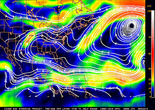
The steering level wind is all westerly for the next few days; thus, the system should generally move west or just north of west over the next few days on a track toward the Leeward Islands of the northeast Caribbean. I expect the system to be located near the Virgin Islands by late in the week as at least a tropical storm. The tricky part of the forecast over the next 3-5 days is what the wind shear will look like as the system moves farther to the north and closer to 15 - 20 degrees north latitude; while not excessive, most of our modes do forecast an increase in shear in this part of the Atlantic which could act to slow/disrupt the organization of the system.
Forecast model tracks are always problematic at this point in a storm's life; there really isn't a defined center of circulation yet for the models to pick up on and, several days down the line, the weather pattern along the east coast and in the western Atlantic is very uncertain. With that said, take the forecast models with a grain of salt over the next few days as there is likely to be several shifts. For now, the forecast model consensus is to take the system well of the east coast of the United States but, again, this is several days down the line. Also, it should be noted, this would require the development of a deep trough of low pressure along the east coast -- something that has not yet happened this summer -- a summer that has been dominated by strong high pressure across the Atlantic and southern tier of the United States. I would not be surprised to see the model tracks start shifting south and west as we head toward week's end.
The bottom line? This wave is likely headed toward the northeast Caribbean Sea toward the end of the week. Beyond that, it is a system that will bear watching for southwest Florida. Elsewhere, there is a tropical wave set to enter the eastern Caribbean later today; some slow development is possible but any system here would stay hundreds of mil to our south. Another wave is located to the east of 91L and also bears watching -- it may also play a role in the organization of 91L because of how close the two are to each other.
Brian


