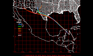
Good morning! The tropical disturbance in the northwest Caribbean continues to show quite a bit of disorganized thunderstorm activity near its center this morning. It's also being affected by some stronger wind shear on the eastern side of the storm (northerly shear in the eastern Gulf of Mexico); this is likely inhibiting real organization at this point in addition to its proximity to land.
The disturbance will move over the northern part of the Yucatan later today and by tomorrow should be back out in the waters of the Gulf of Mexico, a little north of where Alex reemerged about 9 days ago. Remember, the water is very warm in the southwest Gulf, and progressively deeper the farther north you go. Invest 96L will move across the deeper, warmer water and, in a low shear environment, should be able to get more organized as it approaches the lower Texas coast. The second image I've attached is the steering currents and the third is the forecast models; the models are in remarkably good agreement this morning that this tropical moisture is headed toward the Texas coast.
Most of our models (the tropical models) do have this becoming a depression or storm in the western Gulf and I believe this will happen. The environment is just too favorable for development. But, like Alex, strong high pressure over the southeast means this is a western Gulf storm and the eastern Gulf remains protected! That said, depending on whether this develops/how strong it gets, higher seas could again affect the oil slick region and we'll be watching that.
Brian


