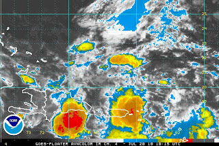
Good morning! The first tropical wave really worth watching here in southwest Florida continues to be a disorganized, but broad, cluster of showers and storms over the northeast Caribbean Sea. There is a surprising amount of convection associated with the wave right now, largely due to the upper level area of low pressure located north of the system. While this wave is producing strong wind shear over the northern half of the wave (greater than 20 knots, essentially prohibitive for any reason organization over the next day or two), it is also helping to carry air away from the tops of some of the thunderstorms. This process, called ventillation, actually fosters new areas of rising area and, in the moist unstable environment where the wave is located, this leads to additional thunderstorm formation. The issue is, though, that the wind shear prevents the storms and moisture from being centered around a specific point -- and until this happens, a circulation really can't develop.
In fact, last night's 10 PM satellite pass did find strong wind associated with the wave (notice the bright red colors north of Puerto Rico on the second image, this indicates wind greater than 20 knots) -- however, the wind is all easterly. So, as of right now, there is really no circulation associated with this wave. Over the next 48 hours, though, as this tropical wave moves toward the west-northwest, wind shear is forecast to weaken and this may allow for some slow organization to begin to occur as it approaches the Bahamas.
There was a shift north in our forecast models; although, this may be temporary given the strength of the ridge of high pressure located across the southeast. Our tropical forecast models indicate a general track toward the WNW placing the wave near the Florida Straits or south Florida by late in the week. As far as strength, right now, only slow organization is expected given the strong upper level wind pattern but it's really much too early to say right now.
At the least, expect an increase in the chance of showers and storms by Friday as the wave approaches. Of course, we'll continue following it for you over the next few days!
Brian


